
As South Africa experiences a dynamic weather pattern over the weekend of Saturday, 26 July, and Sunday, 27 July 2025, residents and travellers are urged to remain alert to various weather warnings issued across provinces. The South African Weather Service (SAWS) has provided important updates highlighting cloudy skies, scattered showers, icy mornings with frost, and strong winds particularly along the coasts, alongside isolated thunderstorms in some regions.
ALSO READ: Weekend Gig Guide: What to Do in Gauteng This Weekend — 25, 26, & 27 July 2025
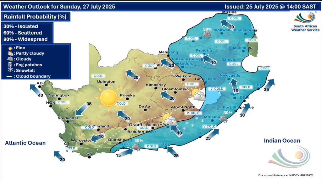
National Overview
A strong ridging high-pressure system following a cold front is sweeping much of the country, pushing icy air masses over the interior. This has resulted in icy mornings and widespread frost particularly in central and northern interior regions. Meanwhile, the southern and eastern coastline can expect strong winds that may impact maritime activities.
The weather pattern includes scattered showers along the southern coastal areas, with isolated showers and thunderstorms developing over parts of the north-eastern interior. Light snow is forecasted for Sunday on the northern high ground of the Eastern Cape. Over the next few days, no new impact-based severe warnings have been issued by SAWS, but caution is advised due to cold and wet conditions in many areas.
Provincial Weather Warnings and Updates
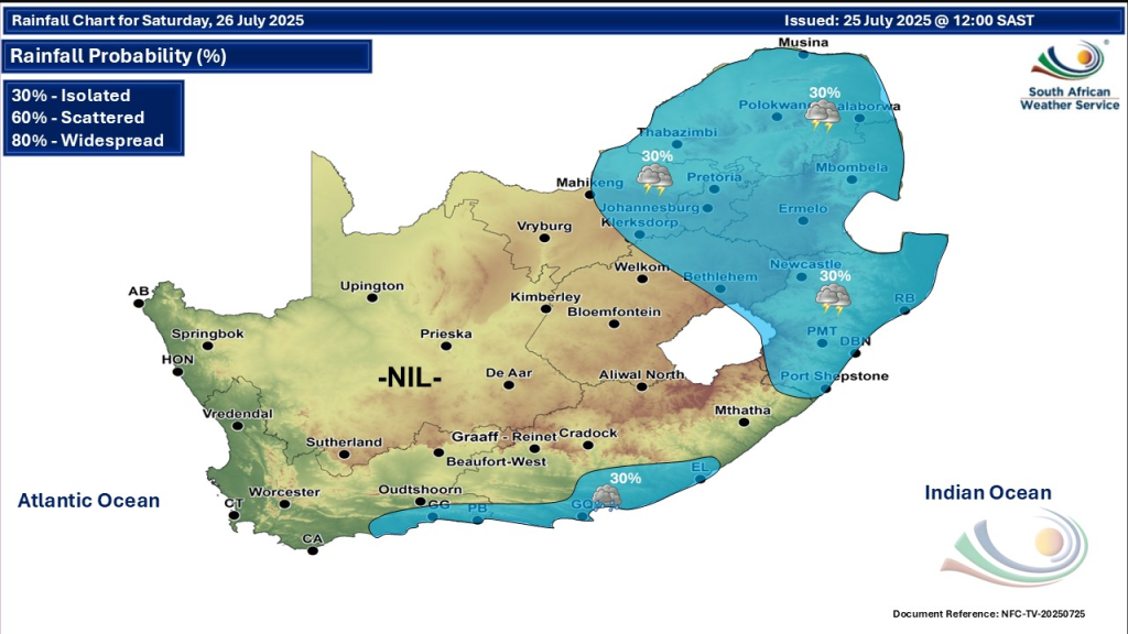
Gauteng
Residents should prepare for partly cloudy, cool conditions with isolated afternoon showers and thundershowers. A high UVB index is expected, so sun protection remains necessary even in cooler weather. A yellow level 2 warning for severe thunderstorms applied the previous day, but no new impact warnings are currently active.
Western Cape
Cloudy and cold weather will prevail, especially inland. Some areas in the extreme south-east will see light rain. Morning fog patches may reduce visibility, so motorists should exercise caution, particularly in the Overberg and southern interior. The cold front advancing over the region has stabilized but continues to keep temperatures low.
Eastern Cape
The province will experience partly cloudy and cold to very cold conditions. Isolated showers and rain will occur mainly in the south and south-eastern parts, with possible light snow over the northern high ground on Sunday. Residents should prepare for chilly mornings and wet road conditions, particularly in rural and elevated areas.
KwaZulu-Natal
The area will have partly cloudy and cool weather, with warm patches in the extreme north-east. Isolated afternoon showers and thunderstorms are expected, notably between the southern and western parts where a yellow level 2 warning for possible severe thunderstorms was previously in effect. These may bring damaging winds, frequent lightning, and heavy downpours, causing localized flooding and disruption.
Mpumalanga and Limpopo
Both provinces will see partly cloudy and cool to warm conditions, with isolated showers and thundershowers. Morning fog patches over the highveld may reduce visibility temporarily. Residents should watch for wet roads and plan accordingly.
Free State, North West, and Northern Cape
These provinces will mostly experience cool to cold weather with partly cloudy skies and isolated showers and thundershowers in eastern areas. The Northern Cape will be colder in the south, with morning fog in some interior parts. Travel delays may occur due to fog and wet roads in these regions.
Marine and Coastal Warnings
The South African Weather Service has issued a yellow level 2 warning for damaging waves and rough seas impacting navigation between Port Alfred in the Eastern Cape and Richards Bay in KwaZulu-Natal. This leads to difficulties in port operations and potential localised disruptions to beachfront activities from Saturday into Sunday. Boaters and coastal communities are urged to heed these warnings.
Safety Tips and Precautions
- Drive carefully in fog-affected areas and during showers to avoid accidents.
- Be prepared for icy conditions and frost in the interior, especially early mornings.
- Protect against strong winds along the southern and eastern coasts; secure loose objects outdoors.
- Avoid unnecessary travel in areas with severe thunderstorm advisories.
- Use sunscreen on sunny breaks due to high UVB index, even in cooler weather.
- Monitor official weather updates regularly for changing conditions.
Stay Safe, Stay Warm
The weekend of 26–27 July 2025 brings a mix of cloudy skies, showers, frost, and strong coastal winds across South Africa. While no new severe impact warnings have been issued, localized disruptions from rough seas, thunderstorms, and cold conditions warrant vigilance. Residents in affected provinces should prepare accordingly and stay updated through reliable sources like the South African Weather Service.