
As spring unfolds in South Africa on the Saturday, 6th and Sunday, 7th of September 2025, the country faces a weather mix that demands attention. Across provinces, conditions will range from fine and cool to warm, with hot spots in certain areas. Clouds will gather, bringing isolated to scattered showers and rain, while damaging winds and severe thunderstorms loom as serious concerns.
SEE FULL FORECAST: Today’s Weather Forecast – Saturday, 6 September 2025
Table of contents
- Nationwide Weather Overview
- Gauteng: Warm to Hot with Wind Hazards
- Free State: Warm, Windy, and Thunderstorm Potential
- KwaZulu-Natal: Cool to Warm, Isolated Showers, and Severe Thunderstorms
- Eastern Cape: Partly Cloudy with Showers and Thunderstorms
- Northern Cape: Warm to Hot with Winds and Fire Danger
- Western Cape: Cool to Warm with Morning Fog, Cloudiness, Winds, and Fire Risk
- Limpopo: Hot with Scattered Storms and Wind Alerts
- Mpumalanga: Hot Spells, Morning Fog, and Thunderstorms
- North West: Warm, Windy, and Possible Thunderstorms
- Safety Tips and Precautions
- Understanding Weather Warnings
- How Weather Affects Daily Life
- Total Lunar Eclipse Details — 7 September 2025
- Stay Updated with Trusted Sources
- Be Weather-Wise This September
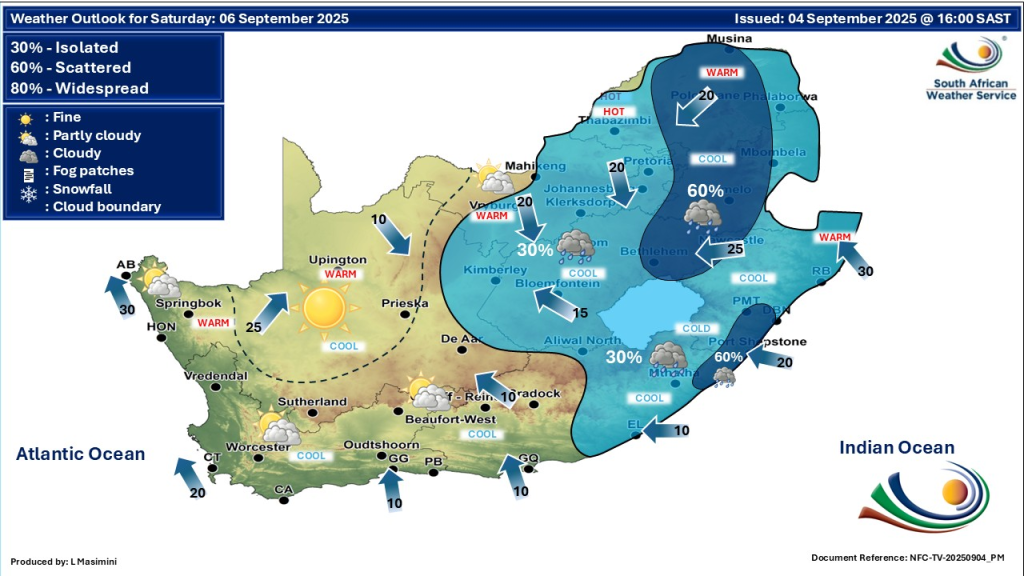
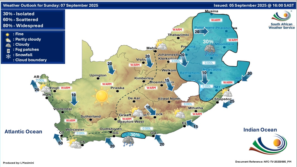
Nationwide Weather Overview
The coming days will deliver a blend of warm to hot temperatures in inland regions, alongside cool coastal pockets. Clouds will thicken intermittently, supporting scattered showers and rain. Notably, damaging winds and severe thunderstorms are forecast, especially inland and in eastern parts of the country. Residents should prepare for sudden weather changes and potential hazards related to storms and wind.
Gauteng: Warm to Hot with Wind Hazards
Gauteng will experience mostly warm to hot weather, with some cooler moments in the early mornings. The province faces an elevated risk of damaging wind gusts on the 6th and 7th, which can affect outdoor activities and structures. The UVB sunburn index will be very high, making sun protection essential during daytime hours. While showers are limited, isolated strong thunderstorms may develop, with heavy rains risking localized flooding.
Free State: Warm, Windy, and Thunderstorm Potential
The Free State will see fine and warm conditions but will become increasingly windy. Wind speeds may damage weak structures and cause discomfort for residents. Thunderstorms are likely to arise late in the day, bringing heavy rain and strong winds. The risk of sudden downpours means staying informed and exercising caution during outdoor activities.
KwaZulu-Natal: Cool to Warm, Isolated Showers, and Severe Thunderstorms
KwaZulu-Natal’s weather will fluctuate between cool coastal areas and warmer inland zones. Isolated showers will happen, primarily along the coast. The region is on alert for severe thunderstorms, some of which could be intense with hail and damaging winds. Residents should monitor updates closely and take all necessary precautions to stay safe from weather-related impacts.
Eastern Cape: Partly Cloudy with Showers and Thunderstorms
The Eastern Cape will experience a mix of partly cloudy skies and isolated to scattered showers and thunderstorms. Coastal areas will remain cooler, while the inland experiences warmer daytime temperatures. Thunderstorm activity carries risks of strong wind gusts and localized flooding. Those in flood-prone areas should prepare for sudden heavy rains.
Northern Cape: Warm to Hot with Winds and Fire Danger
The Northern Cape will see warm to hot temperatures coupled with increasing winds, especially in southern parts. These dry, windy conditions enhance wildfire risks, particularly in rural areas. Fire safety remains a priority given the extremely high fire danger. Occasional isolated showers and thunderstorms may offer brief relief but won’t reduce overall fire risk significantly.
Western Cape: Cool to Warm with Morning Fog, Cloudiness, Winds, and Fire Risk
Western Cape residents start their days with cool conditions and pockets of morning fog. By afternoon, weather turns partly cloudy and warmer in some western coastal regions. Strong southeasterly winds remain a concern, particularly in southern coastal areas. Elevated fire danger persists due to dry conditions balanced against limited rainfall.
Limpopo: Hot with Scattered Storms and Wind Alerts
Limpopo will be hot and mostly dry with occasional scattered thunderstorms, especially during the afternoon. Strong wind gusts may accompany these storms, capable of causing damage. Heat safety is important as temperatures soar, and hydration is advised.
Mpumalanga: Hot Spells, Morning Fog, and Thunderstorms
Mpumalanga’s weather includes early morning fog patches over eastern areas. The day warms up, becoming hot in parts of the lowveld. Thunderstorms will likely develop later, bringing rain and gusty winds. These conditions call for vigilance in affected areas.
North West: Warm, Windy, and Possible Thunderstorms
North West province faces warm and windy conditions with isolated showers and thunderstorms possible in western parts. Windy weather increases risks related to outdoor activities and transport. Isolated heavy rain may cause localized flooding.
Safety Tips and Precautions
- Protect Against Sun Exposure: With high UV indexes in many provinces, wearing hats, applying sunscreen, and avoiding midday sun is crucial.
- Prepare for Strong Winds: Secure loose items and use caution outdoors in areas expecting damaging gusts.
- Stay Informed About Thunderstorms: Monitor weather alerts for severe storm warnings and seek shelter when necessary.
- Fire Danger Awareness: In provinces with high fire risk, avoid open flames and report fires promptly.
- Heat Safety: Drink plenty of water and avoid strenuous activities during peak heat hours.
- Flood Precautions: Residents in flood-prone areas should be alert to sudden heavy rain and follow local safety guidance.
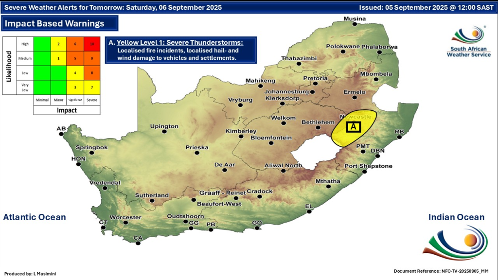
Understanding Weather Warnings
Weather warnings are issued by the South African Weather Service to help protect life and property. They classify risks by severity, from advisory notices to severe weather warnings, based on forecast conditions. It’s important to treat each warning seriously and act on advice given by authorities.
How Weather Affects Daily Life
The mix of weather in early September challenges outdoor plans and travel. Strong winds and storms can delay or disrupt activities. Heat increases health risks, especially for vulnerable groups. Being prepared means adjusting plans, dressing appropriately, and keeping updated on weather changes.
Total Lunar Eclipse Details — 7 September 2025
- Event: Total Lunar Eclipse (Blood Moon) visible across South Africa, including Johannesburg
- Start: 5:49 PM SAST – moon enters Earth’s penumbral shadow
- Totality Begins: ~7:30 PM SAST – moon turns reddish as fully covered
- Maximum Eclipse: 8:11 PM SAST, magnitude 1.362
- Totality Ends: 8:52 PM SAST
- Eclipse Ends: 10:55 PM SAST
- Viewing: Safe to watch with the naked eye; no special equipment needed
- Visibility: May be affected by clouds and scattered showers; check local weather forecasts for clear skies
Stay Updated with Trusted Sources
The South African Weather Service remains the most reliable source for weather warnings and forecasts. Official government websites, local news outlets, and trusted weather apps provide timely updates.
CHECK OUT: Weekend Gig Guide: What To Do in Gauteng This Weekend 5, 6 & 7 September 2025
Be Weather-Wise This September
Spring’s instability continues with varying weather creating both pleasant and hazardous moments. From hot spells to thunderstorms and winds, South Africans must remain cautious. Preparedness, awareness, and responsiveness are key to safely navigating the next few days.