
South Africa faces varied weather conditions on Friday, 15 August 2025. A high fire risk threatens certain provinces, while others prepare for rain and cooler temperatures. This article provides an up-to-date overview of weather warnings for all provinces, including strategies to stay safe.
High fire danger warnings have been issued for the northeastern Northern Cape, northwestern Free State, and western parts of North West. Dry, windy conditions increase wildfire risks. Meanwhile, scattered showers and thunderstorms are forecast in eastern and southern areas, bringing some relief but also potential hazards.
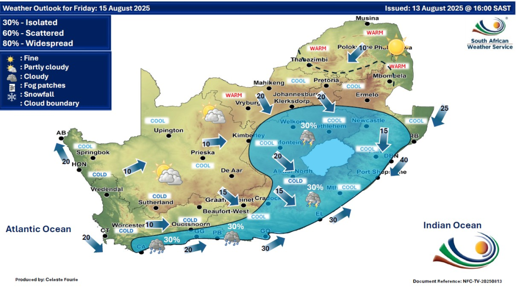
SEE FULL FORECAST: Today’s Weather Forecast – Friday, 15 August 2025
Table of contents
- What Is Fire Danger and Why It Matters
- South Africa’s Weather Warnings for Friday, 15 August 2025
- Rain, Thunderstorms, and Fog: What to Expect?
- Wind and Its Role in Weather and Fire Danger
- Weather and Health: Tips to Stay Safe
- Understanding Weather Terms Used in This Alert
- Why Monitoring Weather Alerts Matters
- How to Prepare for the Coming Days
What Is Fire Danger and Why It Matters
Fire danger is a measure of how likely a wildfire could start and spread. It depends on temperature, humidity, wind speed, and vegetation dryness. Extremely high fire danger means fires can start easily and spread rapidly, threatening lives and property. People must avoid open flames and be vigilant, especially in affected regions.
South Africa’s Weather Warnings for Friday, 15 August 2025
Stay informed about South Africa’s weather on 15 August 2025. High fire risks and rain warnings affect several provinces. Learn safety tips and watch for updates.
Gauteng Province
Conditions will be partly cloudy, ranging from cool to warm during the day. Residents should note a high UVB sunburn index, so sun protection is essential.
Mpumalanga Province
Expect partly cloudy skies with cooler temperatures except in the Lowveld area, which will be warmer. Morning fog may reduce visibility.
Limpopo Province
The weather will be mostly fine and warm, ideal for outdoor activities but requiring sun safety.
North West Province
Partly cloudy, windy, and cool to warm weather is expected. Isolated showers and thundershowers may occur, with fire risk elevated in western areas.
Free State Province
Cool and windy conditions with scattered showers and thundershowers are forecast. Northern and northwestern parts face high fire risk.
Northern Cape Province
This region faces partly cloudy skies, cool to warm temperatures, with isolated showers in the east. Extremely high fire danger is present in the northeastern parts, demanding caution.
Western Cape Province
Cloudiness and cool weather dominate along the west and south coasts. Inland areas will be partly cloudy and cool to cold. Isolated thunderstorms are possible in the southeast.
Eastern Cape Province
Morning fog will affect some areas, clearing to cloudy and cool conditions. Isolated showers and thunderstorms are scattered, especially in the south and northeast.
KwaZulu-Natal Province
Conditions will be partly cloudy and warm, with isolated afternoon showers and thunderstorms, except in the extreme northeast, which will remain dry.
Rain, Thunderstorms, and Fog: What to Expect?
Rainfall and thunderstorms often bring welcome moisture but can cause hazards. Isolated showers and thunderstorms may lead to slippery roads and localized flooding, especially in eastern and southern provinces.
Fog is a thick cloud near the ground that reduces visibility. Motorists should drive carefully during fog events, common in the Eastern Cape and Mpumalanga mornings.
Wind and Its Role in Weather and Fire Danger
Wind spreads fire quickly, making firefighting harder. Winds reaching 30 to 35 km/h are expected in parts of the Northern Cape and North West. Wind also raises dust and aggravates outdoor conditions in dry areas.
Weather and Health: Tips to Stay Safe
- Protect your skin with sunscreen in high UV areas like Gauteng and Limpopo.
- Avoid open fires in zones with high fire danger.
- Drive safely in foggy conditions; reduce speed and use lights.
- Be prepared for sudden showers or thunderstorms and carry rain gear if in affected provinces.
Understanding Weather Terms Used in This Alert
- UVB Sunburn Index: Measures strength of sunburn-causing UV radiation. Higher values mean extra caution outdoors.
- Isolated Showers: Rainfall in small, scattered areas, not continuous.
- Thundershowers: Storms with lightning and thunder that may include heavy rain.
- Fire Danger Index: Likelihood and potential severity of wildfire spread based on environmental factors.
Why Monitoring Weather Alerts Matters
Keeping track of updates from the South African Weather Service (SAWS) and local authorities helps people plan safely and respond quickly to changing conditions. Weather can affect travel, outdoor plans, and health, especially during extreme fire danger or heavy rain.
How to Prepare for the Coming Days
- Stay tuned to weather broadcasts and online resources like WeatherSA.
- Avoid risky behaviour in fire-prone areas.
- Prepare for sudden rain with appropriate clothing and umbrella.
- Help community safety by reporting fires or hazardous conditions promptly.
South Africa’s weather on 15 August 2025 shows a mix of challenges, from high wildfire risks in several provinces to much-needed rain in others. Understanding these conditions and adhering to safety advice will help reduce risks and protect people and property.