



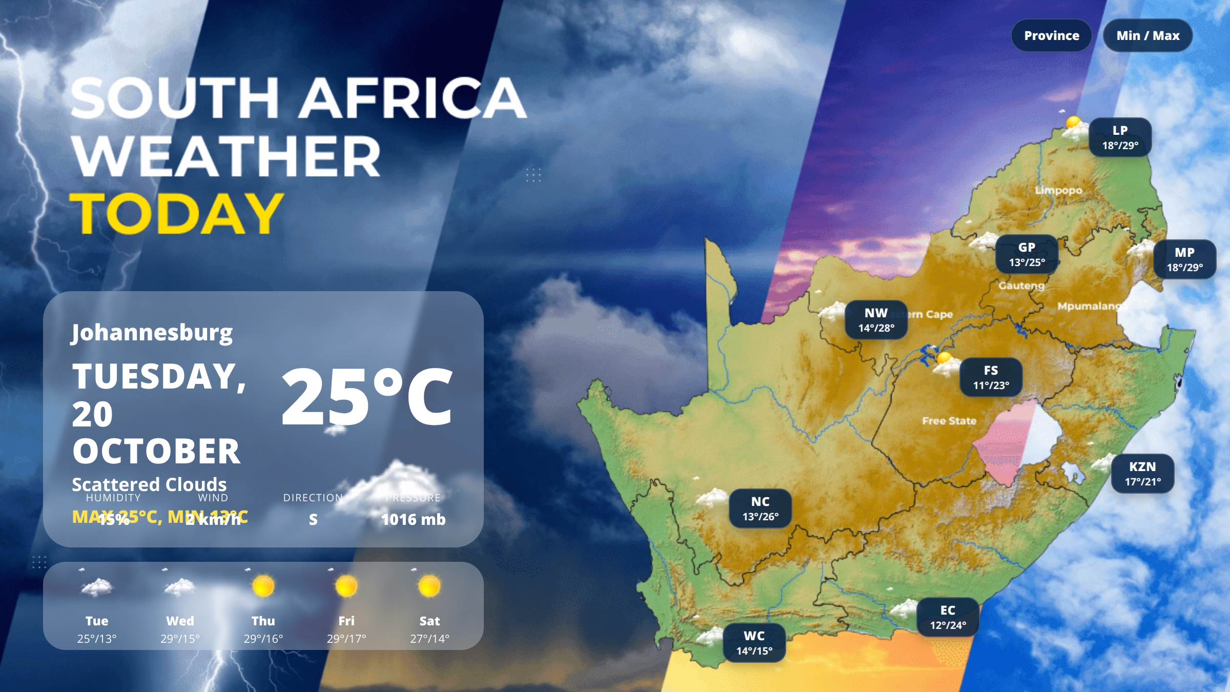
South Africa Weather Today – Tuesday, 20 October 2026
Johannesburg will see temperatures between 13°C and 25°C today under scattered clouds, as spring conditions spread across the interior. Most of South Africa is experiencing mild to warm weather under cloudy skies, with the northern provinces recording the highest temperatures. Limpopo and Mpumalanga are reaching 29°C, while the Western Cape remains notably cooler at just 15°C maximum. Cloud cover dominates the national picture, with no significant rainfall expected across any province.
What This Means for Your Day
Light jackets will be needed early this morning across the interior provinces, particularly in Gauteng, Free State and Northern Cape where minimums have dropped to 11–13°C. Afternoons will warm comfortably into the low to mid-twenties for most regions, making outdoor activities manageable. Coastal areas in KwaZulu-Natal and the Western Cape will experience moderate winds, with gusts reaching 13–16 km/h, so secure loose outdoor items. UV exposure remains moderate to high during midday hours, so sunscreen is recommended for extended time outdoors.
South Africa Weather Highlights
- Warmest regions: Limpopo and Mpumalanga both reaching 29°C
- Coolest region: Western Cape with a maximum of just 15°C
- Widest temperature range: Free State and Gauteng with 12°C variation between morning and afternoon
- Windiest areas: Western Cape and KwaZulu-Natal coast with winds of 13–16 km/h
- National average temperature: 20°C
What to Expect Across the Provinces
Gauteng
Johannesburg will range from 13°C overnight to 25°C this afternoon under scattered clouds. Humidity is notably low at 15%, creating dry conditions throughout the day. Light southerly winds of around 2 km/h mean calm conditions across the province. Pretoria and the East Rand can expect similar conditions with minimal wind disruption.
Limpopo
Polokwane will experience few clouds with temperatures climbing from 18°C to 29°C, making this one of the warmest provinces today. North-northeasterly winds are stronger here at 22 km/h, providing some relief from the heat. Humidity sits at 42%, creating moderately comfortable conditions despite the high temperatures. The Lowveld areas will see similar warmth throughout the afternoon.
Mpumalanga
Mbombela will see broken clouds with temperatures between 18°C and 29°C. Humidity is higher here at 68%, making conditions feel muggier than in neighbouring provinces. Easterly winds of 7 km/h will provide minimal cooling. The Highveld escarpment will experience slightly cooler conditions than the Lowveld, but overall the province remains warm.
North West
Mahikeng will range from 14°C to 28°C under scattered clouds. Low humidity of just 12% creates very dry conditions, so increased water intake is advised. Southwesterly winds of 6 km/h will remain light throughout the day. Rustenburg and surrounding areas will see similar warm, dry weather ideal for outdoor work.
Free State
Bloemfontein will start at 11°C, the coldest morning minimum in the country, before warming to 23°C under few clouds. West-southwesterly winds of 10 km/h will be noticeable, particularly in exposed areas. Humidity of 32% keeps conditions dry. The eastern Free State towards the Lesotho border may experience slightly cooler maximums.
KwaZulu-Natal
Durban will see broken clouds with a narrow temperature range of 17°C to 21°C, typical of coastal moderation. South-southeasterly winds of 13 km/h will affect beachfront areas, making it feel cooler than the actual temperature. Humidity of 53% will create mild, slightly sticky conditions. Pietermaritzburg and inland areas will be a few degrees warmer than the coast.
Northern Cape
Kimberley will range from 13°C to 26°C under scattered clouds. North-northeasterly winds of 6 km/h will remain light. Humidity of 33% ensures dry conditions across this expansive province. The western regions towards Upington may see clearer skies and slightly warmer temperatures than the provincial average.
Eastern Cape
Gqeberha will experience scattered clouds with temperatures between 12°C and 24°C. North-northeasterly winds of 13 km/h will be noticeable along the coast. Humidity of 51% creates moderate comfort levels. Mthatha and the northern interior will see similar cloud cover but slightly different wind patterns.
Western Cape
Cape Town will remain the coolest major centre today with temperatures between 14°C and 15°C under broken clouds. Northwesterly winds of 16 km/h, the strongest in the country, will affect the peninsula and coastal suburbs. Humidity of 68% combined with wind will create a distinctly cool feel. The Winelands and interior may be a degree or two warmer than the immediate coast.
Weekend Outlook
Johannesburg will see a warming trend through the week, with Wednesday reaching 29°C under overcast skies, followed by clear conditions from Thursday onwards. Weekend temperatures will settle around 27–29°C on Saturday with clear skies, ideal conditions for outdoor plans. Most provinces will follow a similar pattern of gradual warming and decreasing cloud cover heading into the weekend.
Weather Tips for Today
- Dress in layers this morning if you’re in the interior provinces, as temperatures will rise significantly by midday
- Apply sunscreen if spending extended time outdoors, particularly in the northern provinces
- Drink extra water in North West and Limpopo where low humidity increases dehydration risk
- Secure loose outdoor items in coastal areas of KwaZulu-Natal and the Western Cape due to moderate winds
- Keep a light jacket handy in Cape Town where the maximum will only reach 15°C
Useful Weather and Travel Links
Looking for more to do after checking the forecast? Explore the latest events in Gauteng and plan your day around the weather.
You can also browse our weather category for more South Africa weather updates and recent forecast articles.
For official forecasting and weather advisories, visit the South African Weather Service.
Last updated: 25 February 2026
This weather hub covers Gauteng-focused alerts, daily forecast context, and practical preparation tips.
Today in Gauteng
Check current alert conditions, possible impact areas, and likely weather trends for the next 24 hours.
7-Day Snapshot
Use this hub to understand short-term changes in rain risk, heat conditions, and storm activity.
Where To Track Live Updates
Safety Checklist
- Plan around severe storm windows.
- Avoid flood-prone routes where possible.
- Monitor official warnings before travel.
FAQ
How often is this page updated?
As new weather alerts and forecast updates are published.