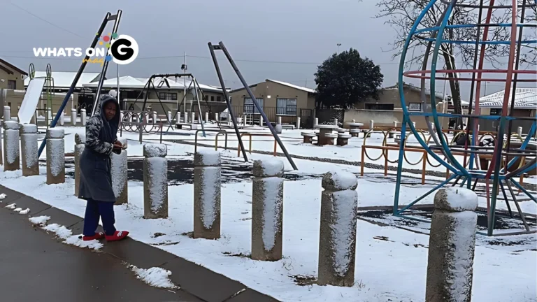
South Africa faces significant weather disruptions on Tuesday, 10 June 2025. A strong cold front, accompanied by a low-pressure system, will bring snow, heavy rain, and damaging winds to many provinces.
ALSO READ: What’s On Gauteng: Top Articles In Gauteng For 09 June 2025
Overview of the Weather System
The cold front, which has already impacted the Western Cape, is now moving across the country, affecting all provinces except Limpopo. This system is responsible for widespread cold temperatures, wet weather, and strong winds. Daytime highs will remain below 10°C in some regions, intensifying the cold conditions. Authorities and residents are urged to prepare for hazardous conditions and heed all weather warnings issued by the South African Weather Service (SAWS).
Gauteng
Gauteng will experience notably cold and mostly dry conditions on Tuesday, 10 June 2025, as a strong cold front moves through the region. Daytime temperatures are expected to reach a maximum of around 11°C, with early morning lows dropping to near freezing, possibly as low as -1°C in some areas. This sharp drop in temperature marks a significant chill compared to usual winter averages.
Residents should prepare for partly cloudy skies with isolated to scattered showers and thundershowers, mainly in the southern and southeastern parts of Gauteng. The South African Weather Service (SAWS) has issued warnings for cold conditions and a chance of snow, particularly in higher altitude areas around Johannesburg and Pretoria, where light snowfall or frost is possible.
The cold front will bring gusty winds, which may increase the wind chill factor, making it feel colder than the actual temperature. These conditions could affect early morning commuters and outdoor activities. It is advisable to dress warmly, use heating safely, and check on vulnerable groups such as the elderly, children, and pets.
Rainfall in Gauteng is expected to be light and sporadic, with only one or two rainy days forecast for the month.
CHECK OUT: What’s On Gauteng: Top Articles In Gauteng For 09 June 2025
Snow Warnings in the Eastern Cape and Free State
Disruptive snowfall is expected mainly in the Eastern Cape and parts of the Free State. SAWS has issued Orange Level 6 warnings — the highest impact level — for snow. This snow could cause road closures, isolate communities, and pose a danger to life.
Additional Yellow Level 2 warnings are in place for disruptive snow in several local municipalities. Snowfall in these areas may lead to livestock losses and traffic disruptions due to icy roads.
Heavy Rain and Flood Risks in the Eastern Cape and KwaZulu-Natal
Heavy and disruptive rain will affect large parts of the Eastern Cape and southern KwaZulu-Natal. Orange level warnings are in place for flooding risks in several municipalities. Flooding may damage property, cut off communities, and cause mudslides. Residents should exercise caution, especially in flood-prone areas.
KwaZulu-Natal’s southern regions face Orange Level 5 warnings for damaging winds and rain, with yellow warnings extending to the central and northern interior. The extreme south of KwaZulu-Natal also has a yellow warning for disruptive rainfall.
Strong Winds and Coastal Hazards
Damaging winds and high waves are forecast along the Eastern Cape and KwaZulu-Natal coasts. An Orange Level 6 warning where winds and waves may cause structural damage, disrupt ports, and pose dangers to vessels at sea. Southern KwaZulu-Natal has an Orange Level 5 warning for damaging winds that could injure people and damage settlements.
Yellow warnings for damaging winds and waves are also in place along the KwaZulu-Natal coast for Tuesday and Wednesday. Inland areas may experience strong interior winds, affecting transport and agriculture.
Mpumalanga, North West, and Limpopo
- Most of the inland provinces will experience cold but mostly dry conditions. Daytime temperatures will range from 12°C to 24°C, with early morning lows near freezing in some areas.
Western Cape
- The Western Cape continues to experience wet and cold weather due to the cold front, with heavy rain warnings still in effect.
Safety and Preparedness Advice
Given the severity of the weather warnings, residents and travellers should:
- Avoid unnecessary travel in snow-affected areas.
- Prepare for possible flooding by securing property and staying informed via official channels.
- Exercise caution near coastal areas due to damaging winds and high waves.
- Monitor updates from the South African Weather Service and local authorities regularly.
Stay Warm, Stay Safe
This cold front is one of the most intense weather systems to hit South Africa this winter. Snow, heavy rain, and strong winds will disrupt daily life. Staying alert and following weather warnings is crucial to ensure safety over the coming days. Residents should stay updated on weather alerts and take necessary precautions to stay warm and safe.


