
A strong cold front is set to sweep across parts of South Africa this weekend, Saturday 9 August and Sunday 10 August 2025. This front brings sharply cooler temperatures, rain showers, strong winds, possible flooding, and rough coastal conditions. Most provinces face weather warnings as this cold front moves inland. Residents must stay alert and prepare for potentially dangerous and disruptive weather.
ALSO READ: Weekend Gig Guide: What To Do In Gauteng This Weekend on 8, 9 & 10 August 2025
Table of contents
- National Weather Warnings: What You Need to Know
- Gauteng: Cooler Weather with Showers
- Western Cape: Rain, Wind and Coastal Flooding
- Mpumalanga: Isolated Showers and Storms
- Limpopo: Mostly Fine and Cooling
- North West: Chilly with Wind Gusts
- Free State: Cloudy and Stormy
- Northern Cape: Windy and Cold
- Eastern Cape: Showers and Cold Air
- KwaZulu-Natal: Wet and Chilly
- What to Expect Over the Next Few Days
- Staying Safe: Tips for Everyone
- Stay Safe & Have A Lovely Day
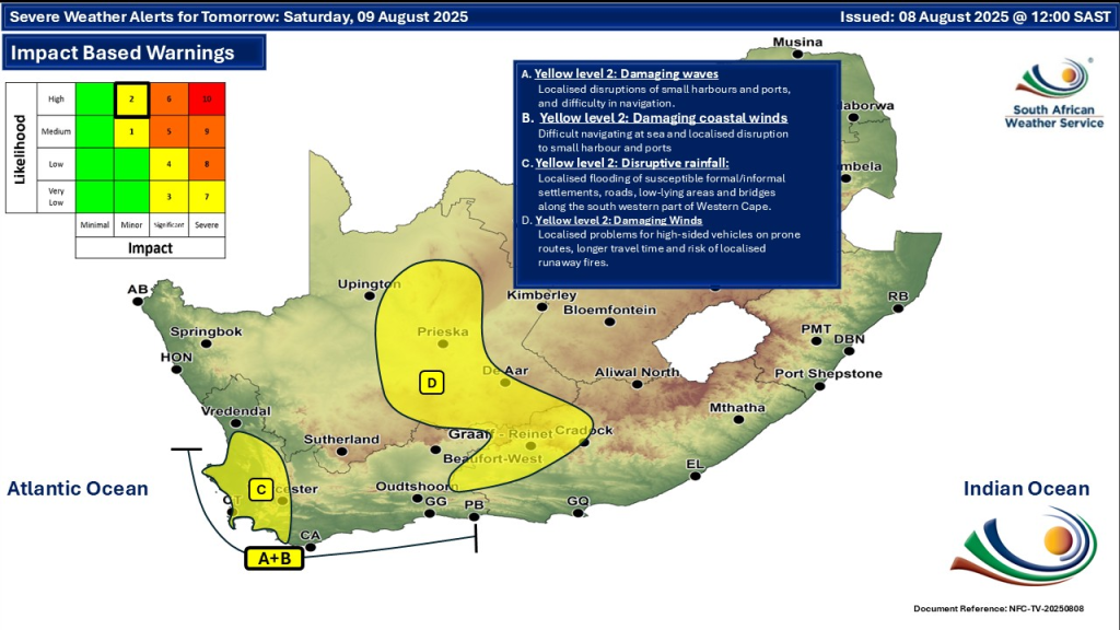
National Weather Warnings: What You Need to Know
The South African Weather Service (SAWS) has issued several warnings for the weekend:
- Yellow Level 2 Warnings for disruptive rainfall causing localized flooding in parts of the Western Cape, including Cape Town and adjacent coastal areas. Flood-prone locations should be especially cautious.
- Damaging Winds expected along the southwestern coast with gusts strong enough to disrupt travel and sea activities. Ports may face temporary closures or delays.
- Rough Seas and Damaging Waves threaten beaches and small boats along the Cape coast stretching from Cape Columbine to Plettenberg Bay.
- Strong Gusty Winds will affect interior regions, increasing risks for outdoor hazards and wildfires in some dry areas.
- Isolated Showers and Storms are forecast in various provinces including Gauteng, Free State, and Mpumalanga.
Gauteng: Cooler Weather with Showers
- Gauteng will experience cooler temperatures, with highs around 15-18°C and cooler mornings.
- Isolated showers and thunderstorms may occur mainly in the southern parts later in the weekend.
- Sunshine is expected in northern areas, but the UV index remains moderate to high, so sun protection is advised.
- Sudden gusts of wind may occur; residents should stay alert.
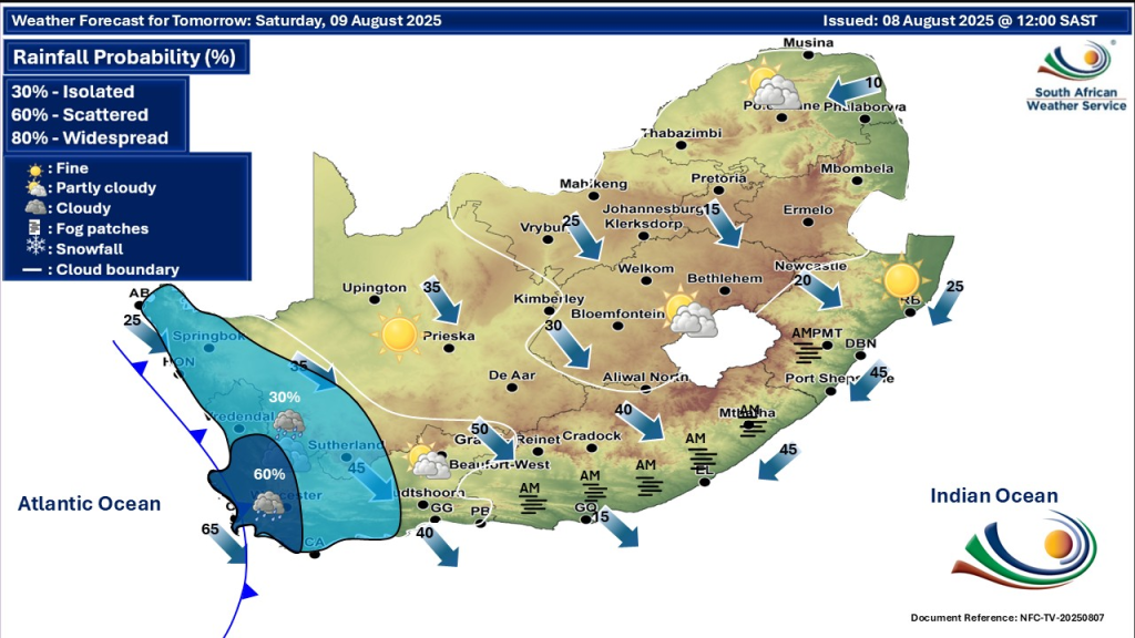
Western Cape: Rain, Wind and Coastal Flooding
The Western Cape faces the brunt of the cold front this weekend:
- Showers and scattered rain will continue, with chances between 30% and 60% especially along the west coast.
- Strong northwesterly to westerly winds will bring gusts reaching 70–90 km/h in exposed areas.
- Coastal flooding has been reported in parts of Cape Town, with some roads blocked by water.
- Residents should avoid unnecessary coastal travel, secure outdoor property, and monitor flood warnings closely.
Mpumalanga: Isolated Showers and Storms
- Mostly partly cloudy and cool with isolated showers and thunderstorms possible in southern and central areas.
- The Lowveld will remain warmer with comfortable temperatures.
- Avoid outdoor activities during thunderstorms for safety.
Limpopo: Mostly Fine and Cooling
- Limpopo will remain mostly fine and mild, with temperatures cooling gradually.
- Some partly cloudy conditions will develop in the evenings.
- The weather should remain stable with minimal rain chances.
North West: Chilly with Wind Gusts
- Conditions will be cool and windy, with fresh northwesterly gusts causing a chilly feel.
- Some isolated rain showers and possible thunderstorms may occur in parts of the province.
- A high fire danger warning remains in effect for western areas due to dry vegetation.
Free State: Cloudy and Stormy
- The Free State will experience cloudy skies with cool temperatures and scattered rain showers.
- Thunderstorms and possible hail are expected, especially in eastern parts.
- Slick road conditions require caution for drivers.
Northern Cape: Windy and Cold
- Northern Cape will be cool with strong winds, especially along the eastern and coastal regions.
- Occasional rain showers and hailstorms are possible.
- Frosty mornings can be expected in inland areas.
Eastern Cape: Showers and Cold Air
- The Eastern Cape will have cold and wet weather, with scattered rainfall and possible light snow in mountainous areas.
- Travel disruptions due to wet and slippery roads are likely.
- Drivers should exercise care, especially in high-lying regions.
KwaZulu-Natal: Wet and Chilly
- KwaZulu-Natal faces cool temperatures and scattered rain showers, with occasional thunderstorms.
- Flood risks exist in some low-lying areas due to heavy showers.
- Fog may reduce visibility in higher elevation locations.
What to Expect Over the Next Few Days
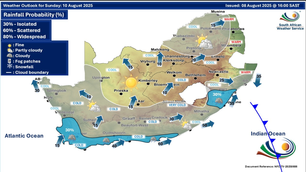
- The cold front will linger into early next week, keeping weather wet, windy, and cool, particularly in southern and central provinces.
- Frost and cold nights will become more frequent in northern and interior regions such as Free State and Northern Cape.
- Coastal residents should stay clear of rough seas and avoid swimming or boating during wave warnings.
Staying Safe: Tips for Everyone
- Drive carefully on wet, slippery, or flooded roads.
- Secure outdoor items and ensure drainages are clear to reduce flood damage.
- Avoid outdoor activities during thunderstorms and periods of strong wind.
- Keep updated with alerts from SA Weather Service official channels.
- Limit exposure to cold conditions, especially for vulnerable groups such as the elderly and children.
- Stay away from the coast during damaging wave conditions.
Stay Safe & Have A Lovely Day
South Africa is facing a sharp reminder of winter this weekend as the latest cold front brings a mix of rain, wind, and chilly temperatures nationwide. By staying informed, taking sensible precautions, and heeding official warnings, residents can stay safe and navigate this weather with confidence. Keep monitoring SAWS for live updates and plan any travel or outdoor activities carefully.