
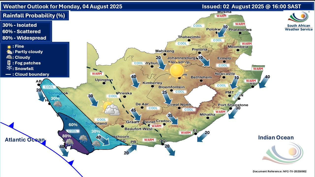
A cold front will make landfall over South Africa’s south-western coast today, Monday the 4th of August 2025, bringing significant weather changes and warnings. The South African Weather Service (SAWS) has issued several alerts affecting provinces across the country. Residents and travellers are advised to take precautions as the cold front moves inland over the next few days.
RELEVANT ARTICLE: Today’s Weather Forecast – 4 August 2025
Table of contents
Cold Front Arrival and Impact
The cold front will first hit the Western Cape this morning, introducing unsettled weather marked by scattered rain and strong winds. Rain will be widespread along the south-west coast, and isolated showers will spread into the Eastern Cape by Tuesday. Coastal areas will experience damaging sea waves, especially between Saldanha Bay and Cape Agulhas this evening. These large waves are expected to disrupt beach and water activities.
Wind Warnings in Central Regions
Strong and gusty winds are forecast over the central parts of the Northern Cape, as well as the Central Karoo in the Western Cape. Winds along the coast will shift from fresh to strong north-westerlies to moderate southerlies as the day progresses. These windy conditions may lead to travel disruptions and caution is advised for those in affected areas.
Fire Risk Alerts
Dangerous fire conditions will continue in parts of the Western and Northern Cape, including the Central Karoo District, and some municipalities like !Khe and Siyathemba. The Eastern Cape also faces fire risks in some areas. The Fire Danger Index (FDI) is high, indicating rapid fire development and spread. Residents should remain vigilant to prevent veld fires and heed any local fire restrictions.
Provincial Weather Updates
Gauteng
Generally fine and cool weather is expected. The UVB sunburn index is high, so sun protection is advised during midday hours.
Western Cape
Expect partly cloudy skies with isolated to widespread rain in western parts. Winds will be strong along the coast, becoming moderate to fresh from the south later in the day. Temperatures will be cool to warm. Coastal activities need caution due to damaging waves.
Eastern Cape
The western half will see fine, warm, and windy conditions, turning partly cloudy by late afternoon. The eastern half remains fine and warm, cooling slightly in northern areas. Winds will moderate and shift direction as evening approaches.
Northern Cape
Fine, windy, and cool to warm weather prevails, with partly cloudy skies and chances of rain in western coastal areas by evening. Coastal winds will be fresh northerlies, becoming moderate later.
Mpumalanga
Fine and cool, though it will be warmer in parts of the Lowveld region. Expect mostly dry conditions with occasional sun.
Limpopo
Fine conditions with temperatures ranging from cool to warm. Clear skies will dominate most of the day.
North West and Free State
Both provinces will experience fine, windy, and cool weather. Winds may affect outdoor plans and travel safety.
KwaZulu-Natal
Weather will be fine with cool to warm temperatures. Coastal winds range from light to moderate, reaching fresh to strong along the northern coastline. Sunburn risk is very high; sunscreen is essential.
Warnings for the Coming Days
The cold front will continue to move eastward into Tuesday, bringing wet weather to more areas of the Eastern Cape while decreasing in the Western Cape. Snowfall is expected in the eastern parts of the Eastern Cape during this period. Coastal waves remain a concern for shoreline activities for the next few days.
Summary and Precautions
- Avoid beach and coastal water activities where strong waves are forecast.
- Prepare for windy conditions when travelling, especially in the Northern Cape and Central Karoo.
- Stay alert to fire warnings in the Western and Northern Cape and Eastern Cape to avoid veld fires.
- Use sun protection in high UVB index areas, particularly Gauteng and KwaZulu-Natal.
- Monitor local updates as weather conditions will evolve with the cold front’s progress.
Small space? Big ideas! Here are 6 Smart and Affordable Ways to Transform Your Tiny Bathroom. Click to uncover clever, budget-friendly tips that make every inch count.
Stay Safe
As the cold front moves steadily across South Africa, it will continue to shape weather patterns through the coming days. Residents and travellers should remain alert to weather warnings, particularly for strong winds, damaging sea waves, and fire risks in vulnerable areas.
Taking precautions: such as avoiding coastal water activities, preparing for gusty winds, and practising fire safety, will help keep everyone safe during this unsettled period. Additionally, sun protection remains vital in regions with high UVB levels.
Staying updated with official information from the South African Weather Service is essential as conditions evolve. By heeding these warnings and planning accordingly, communities across the country can navigate the challenges brought by the approaching cold front with greater confidence and resilience.