
A strong cold front has swept across South Africa on Wednesday, 6 August 2025. This front brings harsh winter weather with cold temperatures, heavy rain, snow, damaging waves, and severe thunderstorms. All provinces face weather warnings. Residents must stay alert and prepare for dangerous conditions.
SEE FULL FORECAST: Today’s Weather Forecast: 06/08/2025
Table of contents
- National Weather Warnings: What You Need to Know
- Gauteng: Cool Weather with Possible Thunderstorms
- Mpumalanga: Showers and Storms in Some Areas
- Limpopo: Mild and Mostly Fine
- North West: Chilly with Fire Danger in Some Areas
- Free State: Cloudy, Cold with Severe Storms
- Northern Cape: Windy, Cold, and Stormy
- Western Cape: Rain and Floods Disrupt the Coast
- Eastern Cape: Cold, Rain, and Snowfall Warnings
- KwaZulu-Natal: Wet and Cold with Flooding Risk
- What to Expect Over the Next Few Days
- Staying Safe: Tips for Everyone
- Stay Safe & Have A Lovely Day
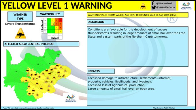
National Weather Warnings: What You Need to Know
The South African Weather Service (SAWS) has issued several important warnings for the coming days. These alerts aim to keep you safe as tough weather hits.
- Severe Thunderstorms and Hail: The Free State and eastern Northern Cape face a yellow Level 1 warning. Small hail could damage homes, vehicles, farms, and livestock.
- Damaging Waves: Coastal regions from Alexander Bay to Plettenberg Bay are at risk from strong waves. This threatens beach activities and small boats.
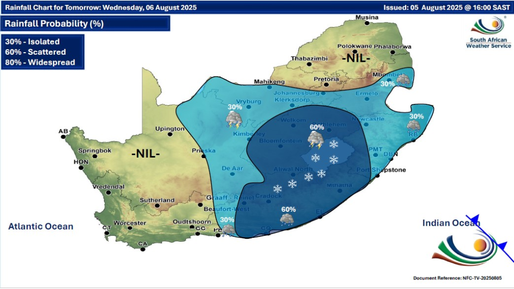
- Snowfall and Cold: Light snow is expected in the northern highlands of the Eastern Cape, with very cold and frosty nights across many areas.
Gauteng: Cool Weather with Possible Thunderstorms
Gauteng will see partly cloudy skies and cool temperatures. Isolated showers and thunderstorms may happen mainly in the south.
- Sunshine: Northern parts can expect some light.
- UV Risk: The ultraviolet index is high, so use sun protection.
- Thunderstorms: Watch for storms late Wednesday and into Thursday.
Mpumalanga: Showers and Storms in Some Areas
Mpumalanga will be partly cloudy and cool. Isolated showers and thunderstorms may occur, especially in southern and central parts. The Lowveld stays warmer.
- Storm Alerts: Thunderstorms likely through Thursday.
- Stay Safe: Avoid outdoor activities during storms.
Limpopo: Mild and Mostly Fine
Limpopo will enjoy mostly fine weather, ranging from cool to warm. The south grows partly cloudy by evening, with milder temps overall.
- Weather Change: Cooler air is moving in from the west.
- Good Conditions: Mostly stable throughout the day.
North West: Chilly with Fire Danger in Some Areas
North West will be partly cloudy, cold to cool, with isolated showers and thunderstorms except in the northeast. The southwest remains cloudier.
- Fire Risk: Western parts have a high fire-danger warning.
- Wind: Fresh northwesterly winds cause gusty, chilly weather.
Free State: Cloudy, Cold with Severe Storms
Free State experiences cloudy and cold weather with scattered showers and thunderstorms.
- Hail Warning: Severe storms may bring damaging hail.
- Road Safety: Slick roads and sudden temperature drops make caution vital.
Northern Cape: Windy, Cold, and Stormy
Northern Cape faces partly cloudy, windy, and cold conditions, especially in the east.
- Storms and Hail: Severe hailstorms forecast for the east.
- Frost: Frosty mornings expected in the southern interior.
- Coastal Alerts: Damaging waves threaten coastal areas.
Western Cape: Rain and Floods Disrupt the Coast
The Western Cape will be cloudy in the southwest and partly cloudy elsewhere. Rain and strong coastal winds persist.
- Damage: Flooding is reported in Cape Town, blocking some key roads.
- Waves: Disruptions possible on west and south coasts from damaging waves.
Eastern Cape: Cold, Rain, and Snowfall Warnings
The western half of the Eastern Cape will stay cloudy and cold with showers and rain. The eastern half will be cold to very cold with rain and light snow in northern highlands.
- Travel: Snow and wet roads may disrupt travel in high-lying areas.
- Safety: Drive carefully on slippery surfaces.
KwaZulu-Natal: Wet and Cold with Flooding Risk
KwaZulu-Natal will be cloudy and cold to cool with isolated showers and thunderstorms. The southwest will feel very cold and wet.
- Flooding: Heavy showers could cause minor flooding.
- Fog: Fog in higher areas may reduce visibility.
What to Expect Over the Next Few Days
The cold front will linger, bringing wet and windy weather eastwards through Thursday. Frosty mornings will occur, mainly in Free State, Northern Cape, and Eastern Cape. Wintry conditions increase risks like flooding, snow build-up, and road closures.
- Coastal Safety: Avoid the surf during damaging wave events.
- Travel Tips: Check weather updates before travelling.
- Health: Dress warmly and avoid prolonged exposure to cold.
Staying Safe: Tips for Everyone
- Drive carefully on icy, wet, or slick roads.
- Protect yourself from sun exposure despite cold weather.
- Stay indoors during intense storms if possible.
- Keep updated with the South African Weather Service alerts.
- Be cautious near coastal areas during wave warnings.
South Africa faces a bold return to winter on 6 August 2025. Stay informed and prepared as this cold front brings challenging weather conditions to many provinces. Your safety is a priority.
Stay Safe & Have A Lovely Day
As South Africa faces the harsh grip of winter on 6 August 2025, staying informed and prepared is essential. The cold front brings a mix of snow, storms, and dangerous coastal conditions that affect every province differently. By following weather warnings, practising safety measures, and planning ahead, residents can navigate this challenging weather with confidence. Keep monitoring updates from the South African Weather Service and take the necessary precautions to protect yourself, your family, and your property during this intense winter period.