
South Africans are advised to prepare for varied weather conditions across provinces on the 23rd and 24th of August 2025, as the South African Weather Service issues important alerts. A mix of fine, cool to warm weather and partly cloudy skies accompanied by showers and rain will prevail in several areas, alongside specific weather warnings to heed for safety and preparedness.
SEE FULL FORECAST: Today’s Weather Forecast – Saturday, 23 August 2025
Table of contents
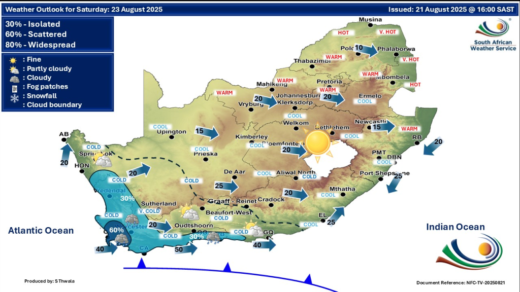
National Weather Overview
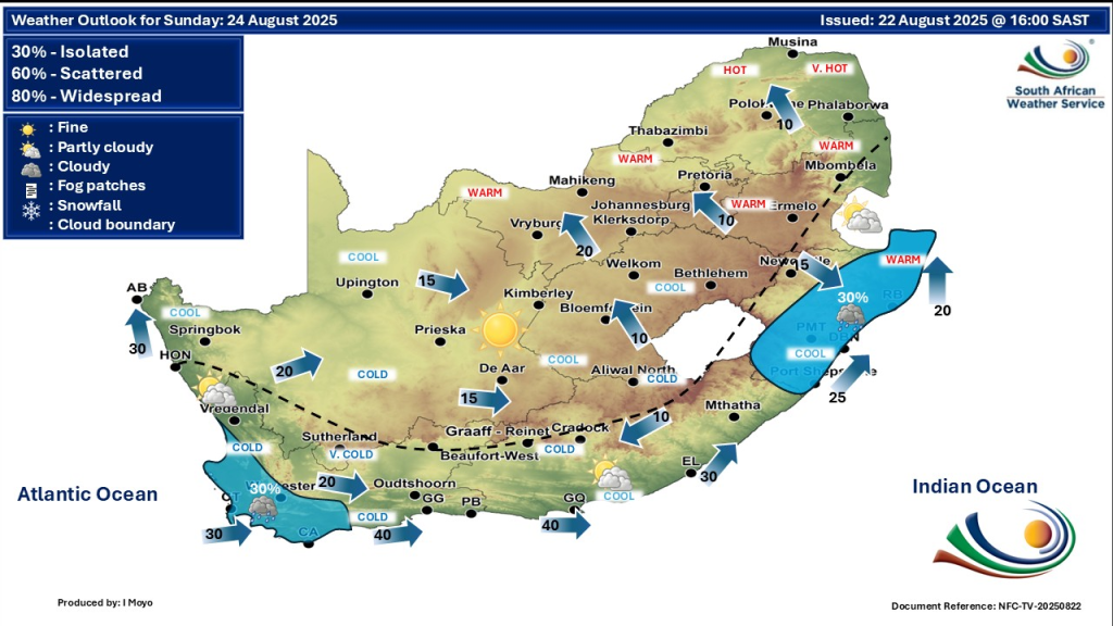
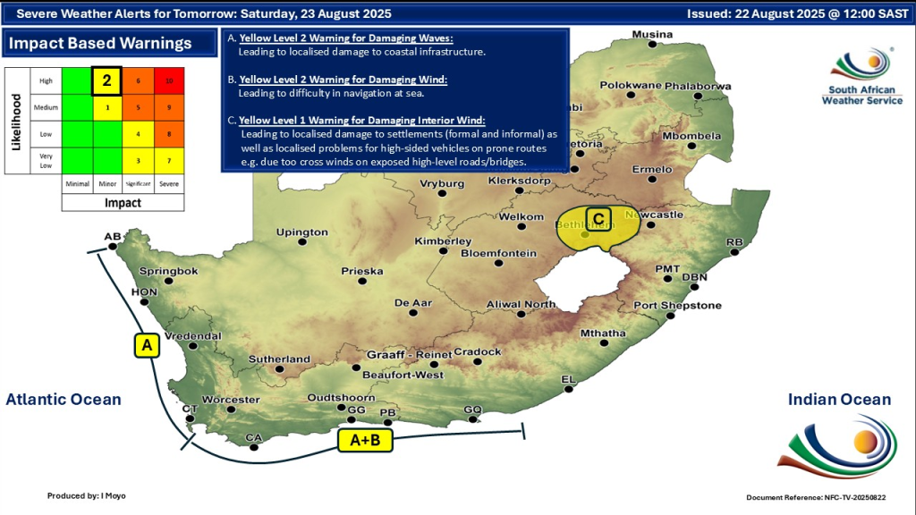
The country will experience predominantly fine and warm conditions in the northeastern and central provinces. However, the southwestern regions face a significant cold front bringing cooler temperatures, showers, rain, and strong windy conditions. Coastal areas, especially along the southwestern and southern coasts, should be alert to potentially damaging waves.
Gauteng Forecast
Gauteng will enjoy fine and warm conditions with a high UVB sunburn index, prompting residents to use sun protection. No severe weather warnings are currently active, but cool mornings are expected, gradually warming during the day.
Western Cape Forecast
The Western Cape faces partly cloudy and cold to cool temperatures, accompanied by isolated showers and rain mainly over southwestern parts until the afternoon. The wind will be strong and gusty along coastal areas, including the south coast and the south-west coast during the evening. Residents and motorists near coastal routes should exercise caution due to expected rough seas and strong winds.
Eastern Cape Forecast
Western parts of the Eastern Cape will see fine yet cold to cool conditions, with cloudy skies bringing light rain in places west of Jeffreys Bay. The eastern half remains partly cloudy and cool from afternoon onwards, with increasing cloud cover in the evening south of the escarpment. Strong south-westerly winds will prevail along the coast at times, posing hazards for maritime and coastal activities.
KwaZulu-Natal Forecast
Morning fog will be present in some interior areas, but overall, KwaZulu-Natal will experience fine, cool to warm weather. Winds along the coast will be light to moderate northerly in the morning, shifting to moderate and fresh southerly to south-westerly later in the day. The UVB sunburn index remains very high, warranting protection measures for those outdoors.
Northern Cape and North West Forecast
The Northern Cape will maintain generally fine and warm weather, though some places in the south may be cooler and partly cloudy. Morning fog is expected in parts of the west. The North West Province experiences fine and warm weather, with no significant warnings.
Free State Forecast
Residents can expect fine and cool to warm weather, with minimal likelihood of rain. Clear and pleasant conditions are forecast.
Limpopo and Mpumalanga Forecast
Both provinces will see fine and warm to hot conditions. Morning fog may occur in lowveld areas of Mpumalanga, but otherwise, clear skies are anticipated.
Weather Warnings: Fire Danger
Extremely high fire danger conditions are expected over the extreme northeastern parts of the Northern Cape, western parts of the North West, northeastern and central Free State, central Eastern Cape, northern KwaZulu-Natal, as well as southern Limpopo and the southern Lowveld of Mpumalanga. Residents and visitors in these areas should be vigilant and avoid activities that could ignite wildfires.
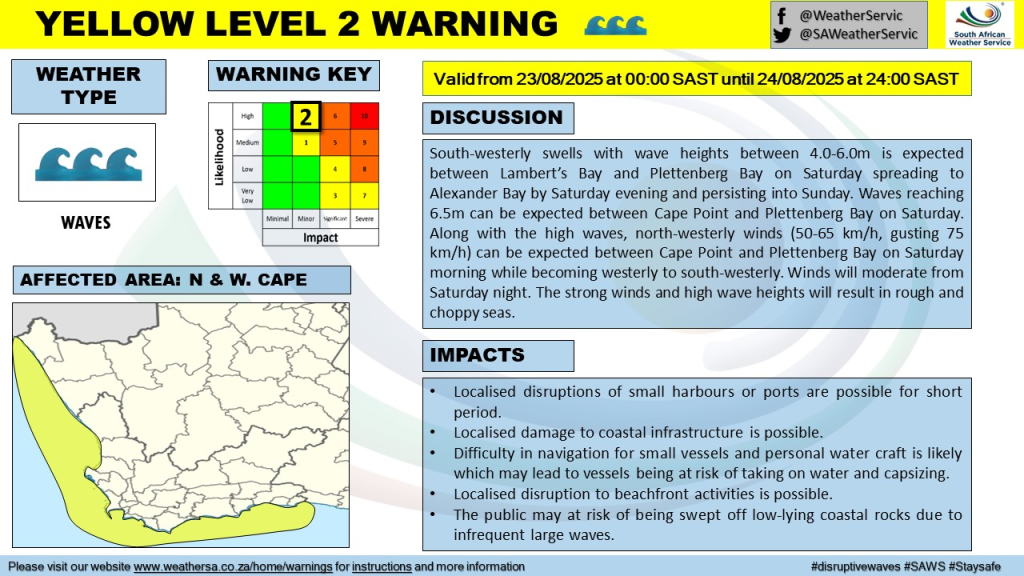
Weather Warnings: Coastal Wave
Damaging waves leading to localized damage of coastal infrastructure are expected between Lambert’s Bay and Plettenberg Bay, extending through to Alexander Bay by the evening of the 23rd and persisting on the 24th of August. Coastal communities and marine operators should prepare for rough seas and take appropriate safety precautions.
Summary and Safety Reminders
- Cold fronts in the southwest will bring wet and windy weather; expect heavy rainfall and strong coastal winds.
- High fire risks in northeastern regions demand careful fire prevention actions.
- Strong winds and damaging waves along the southwestern coastline advise caution.
- UVB levels are high to very high in Gauteng, KwaZulu-Natal, and surrounding areas; sun protection is essential.
- Morning fog in some interior regions may reduce visibility, particularly in Mpumalanga and KwaZulu-Natal.
Stay updated with the latest weather information and heed warnings from the South African Weather Service. Preparation and vigilance will help residents navigate this period of variable weather safely.