
As South Africa moves through the 16th and 17th of August 2025, residents across the provinces are advised to stay alert to significant weather developments. This weather alert serves as a timely reminder of partly cloudy skies, cool to warm temperatures, and isolated showers and thundershowers expected in various regions. Additionally, some areas face further meteorological warnings including wildfire risks, fog, and flooding potential.
SEE FULL FORECAST: Today’s Weather Forecast – Saturday, 16 August 2025
Table of contents
National Weather Overview
Across the nation, the weather will remain mostly partly cloudy with daily temperatures starting cool early in the morning and warming to pleasant, comfortable levels by the afternoon. Isolated showers and scattered thundershowers are forecast for several provinces, although these will be brief and spatially limited. Variability in weather conditions calls for preparedness.
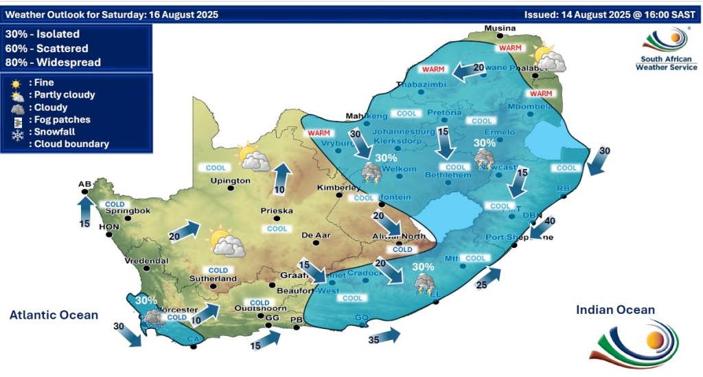
Gauteng
Gauteng is expected to experience partly cloudy skies with scattered to isolated thundershowers primarily during the afternoon and evening hours. Temperatures will range from cool mornings near 12°C warming up to around 24°C in the afternoons. While no major flooding is anticipated, residents should prepare for brief heavy downpours in some areas. Winds will be moderate from the northwest, occasionally fresh in open areas. Fire danger remains elevated, especially around dry zones. Avoid outdoor burning and remain vigilant for fire warnings.
North West
The North West province will see fairly dry conditions transitioning into scattered isolated thundershowers later in the day. Temperatures will be generally warm, with daytime highs near 25°C. However, extremely high fire danger alerts are still active, specifically for the Naledi Local Municipality, driven by gusty winds and parched vegetation. Residents are urged to refrain from open flames and report any signs of fire immediately. Despite showers, the fire risk remains a primary concern.
Limpopo
Limpopo will witness a mix of partly cloudy to cloudy conditions with scattered isolated thundershowers in the afternoons and evenings. The Lephalale area is under an extremely high fire danger warning due to dry conditions and gusty winds. Typical temperatures will reach highs of around 25°C during the day while mornings start at about 11°C. Showers may cause slippery roads, so caution is advised while driving. Avoid any fire hazards and heed all local warnings.
KwaZulu-Natal
KwaZulu-Natal is forecast to experience isolated thundershowers and showers primarily during the afternoon, with partly cloudy skies prevailing in the morning. Temperatures will be warm but mild, ranging between 14°C in the early hours to around 23°C in the afternoon. Heavy showers could lead to localized flooding in low-lying and poorly drained areas. Motorists should be alert to wet and slippery roads and avoid parking in flood-prone zones. Winds are moderate and predominantly northwesterly.
Free State
In the Free State, partly cloudy conditions will mix with isolated showers and thundershowers mostly in the afternoons and early evenings. Temperature swings will see lows near 10°C rising to highs near 24°C. While significant flooding is not expected, localized water accumulation in low areas may occur following heavy showers. Wind speeds will remain moderate, contributing to some cooling during evening hours. Residents should remain cautious outdoors during storm periods.
Eastern Cape
The Eastern Cape will experience partly cloudy mornings with isolated thundershowers and showers developing mainly in the afternoon. Heavy rain in some regions increases the risk for localized flash flooding, especially in low-lying and flood-prone areas. Temperatures will vary from cooler mornings around 12°C to pleasant daytime highs near 22°C. Residents and travelers should avoid flood-susceptible areas and monitor weather updates closely.
Western Cape
The Western Cape will begin the day with patches of morning fog, particularly in coastal and valley areas. Skies will clear to partly cloudy, with isolated showers possible later in the afternoon. Temperatures will feel cooler, with early morning lows approaching 11°C, warming modestly to 19-20°C by afternoon. The fog may reduce visibility temporarily during early hours, making cautious driving important. No significant weather warnings are currently in effect.
Northern Cape
Residents of the Northern Cape will start their days with isolated fog patches in some regions, transitioning into partly cloudy skies with occasional isolated showers expected during afternoon hours. Temperature ranges will be broader here, with morning lows near 8°C and daytime highs reaching 22°C. Winds will be light to moderate, and the environment remains relatively dry. Drivers should be cautious of reduced visibility caused by fog in the early mornings.
Mpumalanga and Limpopo Highlands
Mpumalanga and the surrounding Limpopo Highlands will experience isolated showers and thundershowers, mainly from midday into late evening. Temperatures will be moderate, with highs around 23-24°C and cooler mornings near 10-12°C. Rainfall may cause wet and slippery roads, so commuters and pedestrians should exercise caution. Weather conditions will be variable, and sudden temperature drops may be felt following scattered storm activity.
Wind and Temperature Outlook
- Winds will primarily blow from the northwest, ranging from fresh to strong in some coastal and high elevation areas.
- Temperature lows will reach approximately 10°C during early mornings, with daytime highs nearing 25°C depending on the region.
- No heatwave or heatstroke conditions are anticipated; however, layering is recommended in response to chilly mornings.
Important Advice for the Coming Days
- Continuously monitor local weather updates via reputable channels.
- Be prepared for varying weather by carrying umbrellas or raincoats and piggybacking on official emergency alerts.
- Due to prevailing fire danger warnings in the north, avoid any fire-starting activities outdoors.
- Take care when driving or walking during wet and foggy conditions.
INTERESTING READ: Inside South Africa’s Plan to Address the Worldwide Wildfire Emergency
Stay Safe
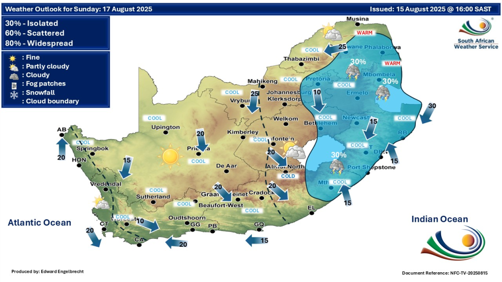
The weather for August 16 and 17, 2025, will be characterized by partly cloudy skies with cool starts and gradually warming afternoons. Isolated precipitation in the form of showers and thundershowers will mainly impact eastern, northeastern, and southern provinces. A heightened wildfire risk remains in select northern municipalities, necessitating ongoing vigilance. Meanwhile, fog and cooler temperatures in the western provinces add variety to the nationwide weather scenario.
Stay informed, stay safe, and plan activities according to evolving weather conditions.