
Table of contents
- Overview of Thursday’s Weather Patterns
- Fire Danger Warnings in Northern Cape and North West
- Thunderstorms and Heavy Rain Warnings
- Provincial Weather Summaries for Thursday, 14 August 2025
- Gauteng
- Northern Cape
- North West
- Free State
- KwaZulu-Natal
- Eastern Cape
- Western Cape
- Mpumalanga
- Limpopo
- No Snow, Frost, or Major Flood Alerts
- Safety Tips and Precautions
- Summary of Key Weather Alerts
- How to Stay Updated
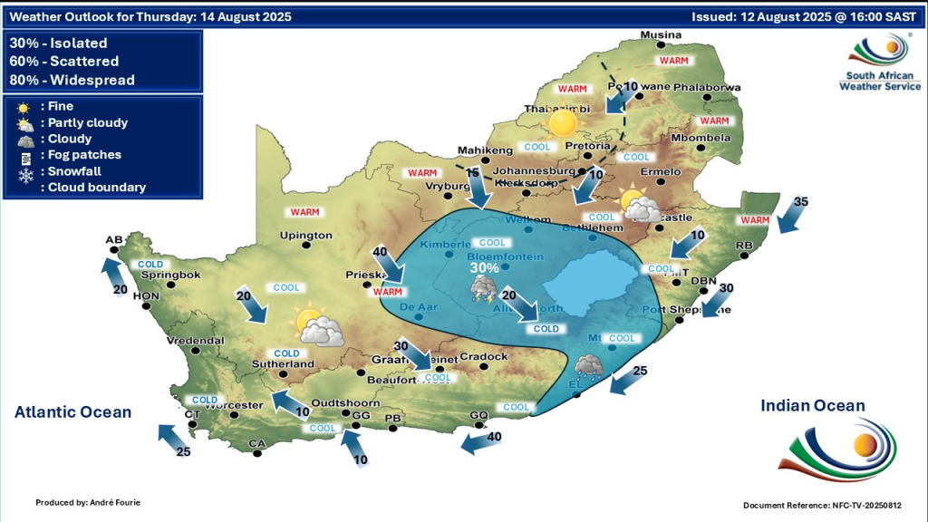
Overview of Thursday’s Weather Patterns
A changing weather system affects much of South Africa on Thursday, 14 August. Cold fronts, thunderstorms, and wind patterns are creating mixed conditions. While some areas may experience showers and thunderstorms, others face dry, windy weather with fire risks. Coastal regions see fog and rough seas. Knowing these weather patterns helps residents plan and stay safe.
SEE FULL FORECAST: Today’s Weather Forecast – Thursday, 14 August 2025
Fire Danger Warnings in Northern Cape and North West
Very high fire danger is declared in the Northern Cape and North West provinces due to dry, windy weather. Fires can spread rapidly in these conditions. Residents must avoid open flames and report any fires immediately. Wildfires cause damage to property and threaten lives. Staying cautious is crucial in these provinces.
Thunderstorms and Heavy Rain Warnings
Thunderstorms are expected in parts of the Northern Cape, Free State, and Eastern Cape. The Eastern Cape’s eastern areas have a Level 2 yellow warning for severe thunderstorms. These storms can bring heavy rain, strong winds, lightning, and hail. Localised flooding and power disruptions may occur.
Provincial Weather Summaries for Thursday, 14 August 2025
The northern provinces overall experience a mix of mild to warm weather, morning fog in some valleys, and scattered afternoon showers or thunderstorms. Fire danger is less severe here compared to the west but vigilance remains key in dry areas.
Gauteng
Gauteng experiences mild to warm conditions with isolated afternoon thundershowers possible. Morning fog is expected in parts, lowering visibility briefly. The UV index is very high, so sun protection is important during outdoor activities.
Northern Cape
The Northern Cape faces very high fire danger due to dry, windy weather. Thunderstorms with heavy rain, hail, and lightning may develop in some areas. Residents must remain vigilant against wildfire risks and sudden storms.
North West
North West province shares the Northern Cape’s extreme fire danger warning. Weather remains mostly dry and windy, increasing fire hazards. Afternoon isolated thundershowers are possible, which may bring temporary relief.
Free State
Warm to hot temperatures prevail in the Free State with morning fog patches. Afternoon showers and thunderstorms are expected, bringing gusty winds and localized heavy rain. Be alert for sudden weather shifts during the day.
KwaZulu-Natal
Partly cloudy skies dominate KwaZulu-Natal, with morning fog along coastal zones. Coastal winds range from moderate to occasionally strong, especially in southern areas. Drivers and mariners should exercise care in affected locations.
Eastern Cape
The Eastern Cape has mixed conditions: eastern parts face a Level 2 yellow severe thunderstorm warning, with risks of heavy rain, hail, and flooding. Interior areas see warm temperatures with morning fog and afternoon showers.
Western Cape
A cold front sweeps through the Western Cape, causing cool, cloudy, and foggy weather. Rain and strong winds are expected, particularly along the coast near Cape Town. Rough seas prevail, posing hazards to marine and coastal activities.
Mpumalanga
Mpumalanga experiences mild weather with breaks of sunshine. Morning fog is likely, especially in valleys and low-lying areas. Afternoon isolated thundershowers may pass through, so remain cautious when outdoors.
Limpopo
Limpopo has generally warm conditions with morning fog patches. Showers and possible thunderstorms occur during the afternoon. The UV index climbs very high, highlighting the importance of sun safety precautions.
No Snow, Frost, or Major Flood Alerts
Currently, there are no snow or frost warnings in South Africa. However, the interior remains cold in the mornings and evenings, so wearing warm clothing is advisable. Apart from localized flood risks caused by thunderstorms, no significant flood alerts are active.
Safety Tips and Precautions
- Avoid fire hazards in high fire danger areas by not using open flames outdoors.
- Monitor local storm warnings to avoid flood-prone zones during heavy rains.
- Use sun protection due to the high UV index, especially in Gauteng and Limpopo.
- Exercise caution on coastal roads and during marine activities because of strong winds and rough seas.
- Dress warmly in the early mornings and evenings to stay comfortable in cool interior areas.
Summary of Key Weather Alerts
- Extremely high fire danger in Northern Cape and North West.
- Severe thunderstorms with a Level 2 yellow warning in the Eastern Cape.
- Cold front causing rain, fog, and strong winds in the Western Cape.
- Mild temperatures with isolated showers in Gauteng and provinces nearby.
- Windy conditions along the KwaZulu-Natal coast.
- No snow or frost warnings; localized flood risk from thunderstorms.
Take these alerts seriously to protect yourself, family, and property during this mixed weather period. Preparedness is key to weathering the changes safely.
How to Stay Updated
For the most accurate and current weather information, visit the South African Weather Service (SAWS) official website and follow their daily updates. Weather conditions can change quickly, so regular monitoring helps you stay prepared.