
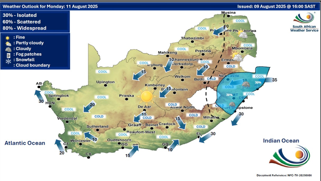
As South Africa faces a changing weather pattern on Monday, 11 August 2025, residents across the provinces should stay alert to important weather updates and warnings. Partly cloudy skies with isolated showers and thundershowers will affect the central and eastern parts of the country, while much of the rest of South Africa will experience fine, cold to cool conditions.
SEE FULL FORECAST: Today’s Weather Forecast – Monday, 11 August 2025
Table of contents
- Overview of Weather Conditions for 11 August 2025
- 1. Gauteng: Warm with Afternoon Thundershowers and High UV Index
- 2. Mpumalanga: Morning Fog, Warm Day, Isolated Thunderstorms in Western Highveld
- 3. Limpopo: Mostly Fine in East, Showers in Southwest
- 4. North West: Warm to Hot with Isolated Thunderstorms
- 5. Free State: Warm to Hot, Morning Fog Patches and Afternoon Showers
- 6. Northern Cape: Cool with Morning Fog on the Coast, Hot and Windy Inland
- 7. Western Cape: Partly Cloudy and Cool Along Coast, Cold Front Moving In
- 8. Eastern Cape: Variable Weather with Morning Fog, Cloud, and Afternoon Thunderstorms
- 9. KwaZulu-Natal: Partly Cloudy with Morning Fog and Strong Coastal Winds
- Key Weather Warnings and Safety Advisories
- Preparing for Monday’s Weather
- Understanding the Weather Terms
- Have A Lovely Day
Overview of Weather Conditions for 11 August 2025
The central and eastern regions will experience partly cloudy conditions with isolated showers and thundershowers, mainly in the afternoons. These thunderstorms might bring localised heavy rain, gusty winds, lightning, and minor flooding in low-lying areas. Elsewhere, the weather will remain mostly fine, but temperatures will range from cold in the interior to cool along the coasts.
1. Gauteng: Warm with Afternoon Thundershowers and High UV Index
Gauteng will see warm, partly cloudy weather, with isolated thundershowers likely in the afternoon. The UVB sunburn index is very high, so it is important to use sun protection when outdoors. Drivers and pedestrians should be aware of lightning risks during storms.
2. Mpumalanga: Morning Fog, Warm Day, Isolated Thunderstorms in Western Highveld
Morning fog is expected along the escarpment. Skies will clear to partly cloudy with warm temperatures. In the west of the Highveld, isolated showers and thundershowers are forecast during the afternoon. Drive cautiously in foggy areas early in the day.
3. Limpopo: Mostly Fine in East, Showers in Southwest
The eastern part of Limpopo will remain mostly fine and mild, while the southwest will experience partly cloudy skies with isolated showers and thundershowers developing in the afternoon. Residents should stay updated on heavy showers’ possibility.
4. North West: Warm to Hot with Isolated Thunderstorms
North West Province is expected to have warm to hot weather with partly cloudy skies and scattered thundershowers. These can reduce visibility and cause localized disruption.
5. Free State: Warm to Hot, Morning Fog Patches and Afternoon Showers
The Free State will be warm to hot with mostly fine weather. However, morning fog patches are expected in the extreme east, clearing by mid-morning. Later, the province will turn partly cloudy with isolated showers in the afternoon, mainly in the east.
6. Northern Cape: Cool with Morning Fog on the Coast, Hot and Windy Inland
Coastal areas will experience morning fog and cool temperatures. Inland, it will be mostly fine and warm to hot. Central and eastern Northern Cape will be hot to very hot and windy, with isolated showers and thundershowers in the extreme east. High wildfire risk demands caution.
7. Western Cape: Partly Cloudy and Cool Along Coast, Cold Front Moving In
The Western Cape will be partly cloudy and cool along the coast with fog patches in the morning. Inland areas will have fine and hot to very hot weather. A cold front is expected, bringing windy, wet, and cool conditions, especially along the south and southwest coast. There is a level 2 yellow warning for disruptive rainfall and damaging winds that could affect coastal activities.
8. Eastern Cape: Variable Weather with Morning Fog, Cloud, and Afternoon Thunderstorms
- Western half: Warm with coastal cloud cover; isolated thunderstorms mostly in northern and eastern parts.
- Eastern half: Morning fog patches, cloudy along the coast early, then fine, warm to hot with scattered afternoon thunderstorms.
A level 2 yellow warning is active for severe thunderstorms in the eastern portions, with risks of damaging winds, hail, and lightning.
9. KwaZulu-Natal: Partly Cloudy with Morning Fog and Strong Coastal Winds
Partly cloudy skies with interior morning fog. Winds along the coast will be moderate to fresh northerly to north-easterly, reaching strong at times in the south. Drivers and mariners should be cautious of gusts.
Key Weather Warnings and Safety Advisories
- Severe Thunderstorms: A level 2 yellow warning covers the eastern Eastern Cape. These storms may bring damaging winds, hail, and lightning strikes. Stay indoors when storms approach and avoid open fields.
- Extremely High Fire Danger: Central and southern Northern Cape, extreme southern Free State, northeastern Western Cape, and the western half of the Eastern Cape face a very high risk of wildfires. Avoid open flames and report any fires immediately.
- Disruptive Rainfall and Strong Winds: The Western Cape will experience a cold front, causing disruptive rainfall, strong winds, rough seas, and possible local flooding, especially in Cape Town and southwestern coastal areas.
- Morning Fog: May reduce visibility in Western and Eastern Cape and parts of KwaZulu-Natal. Use headlights and reduce speed on roads during foggy conditions.
- No Snow or Frost Warnings: While no significant snow or frost is expected on 11 August, chilly to cold temperatures will prevail in most interior areas, so dress warmly, especially in early mornings and evenings.
- Hot and Humid Pockets: Certain interior areas of the Eastern Cape may experience hot, humid conditions, increasing discomfort where thunderstorms occur.
Preparing for Monday’s Weather
Residents should:
- Monitor updates from the South African Weather Service for any changes in warnings.
- Carry sun protection in Gauteng and other warm regions.
- Be cautious driving in foggy or storm-affected areas.
- Exercise extreme caution in fire risk zones.
- Avoid unnecessary travel during severe weather, especially near affected coastal zones.
- Secure outdoor items that can be blown by strong winds.
Understanding the Weather Terms
- Partly Cloudy: Sky is between 30-70% covered with clouds, allowing sunlight through.
- Isolated Showers: Rain is expected in scattered spots, not widespread.
- Thundershowers: Showers accompanied by thunder and lightning.
- Level 2 Yellow Warning: Indicates potentially hazardous weather that requires preparedness.
- Cold Front: A cooler air mass replaces warmer air, often causing temperature drops, wind, and precipitation.
- Fire Danger: Indicates the likelihood of fire ignition and spread.
Have A Lovely Day
As weather conditions continue to evolve throughout the day, staying informed is crucial for your safety and well-being. Regularly check updates from the South African Weather Service and reliable local media to receive timely information on any changes to warnings or forecast developments.
By preparing adequately; whether it’s protecting yourself from strong sunshine, driving carefully through fog or storms, or exercising caution in high fire-risk areas; you contribute to your safety and that of your community. Weather can be unpredictable, but with the right knowledge and precautions, you can face the day’s challenges confidently and protect yourself and those around you. Keep alert, plan ahead, and take all necessary measures to navigate Monday, 11 August 2025, safely across South Africa.