
South Africa’s weather on 5 September 2025 presents mixed conditions across the provinces. Residents can expect partly cloudy skies over the southern and eastern regions, accompanied by isolated showers and thundershowers. Elsewhere, the weather will be mostly fine, warm to hot, with cooler temperatures in some southern areas.
SEE FULL FORECAST: Today’s Weather Forecast – Friday, 5 September 2025
Table of contents
- Partly Cloudy Skies with Isolated Showers in the South and East
- Warm to Hot Weather Dominates Elsewhere
- Cooler Temperatures in Some Southern Areas
- Fire Danger Remains High in Multiple Provinces
- Summary of the Provincial Weather Conditions for South Africa on Friday, 5 September 2025:
- Wind Warnings in Interior and Coastal Areas
- UV Exposure: Take Precautions
- No Severe Cold Fronts, Snow, or Flood Warnings
- Weather Outlook for the Next Few Days
- How to Prepare for Today’s Weather
- Stay Informed with Official Sources
Partly Cloudy Skies with Isolated Showers in the South and East
The southern and eastern parts of South Africa will experience partly cloudy conditions today. Isolated showers and thundershowers may occur particularly in the Eastern Cape, KwaZulu-Natal, and parts of the Western Cape. These showers are generally isolated, meaning localized spots may see rain, while others remain dry.
- Eastern Cape can expect cloudy periods with light showers in the western areas, while the eastern half will experience partly cloudy skies with possible isolated thundershowers.
- KwaZulu-Natal will begin fine in the morning, then move to partly cloudy weather with isolated showers and thundershowers in the afternoon.
- Western Cape will see partly cloudy and cooler conditions, with light rain along the south-eastern coast later in the day.
These conditions bring relief from the dry spell in these areas but also warrant caution for localized flooding or slippery roads during rainfall episodes.
Warm to Hot Weather Dominates Elsewhere
Most of the rest of the country will face fine weather with warm to hot temperatures typical for early spring. Regions such as Gauteng, Northern Cape, North West, and parts of Limpopo and Mpumalanga will enjoy sunny to partly cloudy skies with temperatures ranging between the mid-20s to mid-30s Celsius.
- Northern Cape and North West will see very warm to hot days, combined with dry and windy conditions.
- Gauteng will experience warm conditions under mostly clear to partly cloudy skies. UV index levels remain high, calling for sun protection measures.
- Limpopo and Mpumalanga will trend warm to hot with some morning fog and partly cloudy afternoons.
These conditions are typical for the season but call for hydration and sun protection, particularly for outdoor activities.
Cooler Temperatures in Some Southern Areas
Some southern and south-western coastal regions will experience cooler temperatures, especially as evening approaches. This includes parts of the Western Cape and the interior Southern Cape.
- Nighttime temperatures in these regions can dip to cooler levels due to clear skies and reduced cloud cover.
- Daytime temperatures will still be moderate but noticeably cooler than the interior provinces.
Residents and visitors should be prepared for temperature changes, especially in morning and evening hours.
Fire Danger Remains High in Multiple Provinces
A significant weather concern remains the extremely high fire danger across various provinces, especially where dry and windy conditions prevail.
- The Northern Cape, North West, Free State, Gauteng, and Limpopo are all under alerts for very high fire risk.
- Winds reaching speeds of up to 40 km/h in some interior locations contribute to the fire hazard.
- Residents should avoid activities that may spark fires and follow local fire ban regulations strictly.
This situation demands vigilance to prevent wildfires, which could cause property damage and threaten lives.
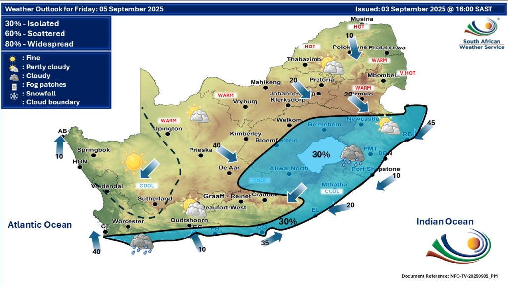
Summary of the Provincial Weather Conditions for South Africa on Friday, 5 September 2025:
| Province | Weather Conditions | Temperature Range | Notable Warnings/Notes |
|---|---|---|---|
| Eastern Cape | Partly cloudy, isolated showers & thundershowers | Cool to mild | High fire danger in some areas |
| KwaZulu-Natal | Fine early, turning partly cloudy with isolated showers & thundershowers | Mild to warm | High fire danger in northern & western parts |
| Western Cape | Partly cloudy, cool, light rain on south-east coast | Cool | High UV levels |
| Northern Cape | Fine, warm to hot, windy, isolated showers in south-east | Hot | Extremely high fire danger |
| North West | Fine, warm to hot, windy | Hot | Extremely high fire danger |
| Free State | Fine, warm, windy, isolated showers | Warm | Very high fire danger |
| Gauteng | Partly cloudy, warm | Warm | High UV index, fire danger |
| Mpumalanga | Warm to hot, fog in escarpment mornings | Warm to hot | Fire danger present |
| Limpopo | Warm to hot, partly cloudy | Warm to hot | Fire danger present |
| Southern Cape | Cooler temperatures, partly cloudy | Cool |
Wind Warnings in Interior and Coastal Areas
Besides fire risk, gusty to strong winds are forecasted in many interior regions and along coastal areas, particularly the southwest coast.
- Wind speeds could reach up to 40 km/h in affected areas.
- These winds may cause discomfort, disrupt outdoor activities, and increase fire spread potential.
- Mariners and coastal visitors should observe caution due to choppy sea conditions.
Wind effects can also exacerbate dust conditions inland, reducing visibility and air quality. It is advisable to secure loose objects outdoors and limit exposure to dusty environments.
UV Exposure: Take Precautions
The UVB sunburn index remains high across much of South Africa.
- Gauteng, Limpopo, and Mpumalanga especially show elevated UV levels.
- Exposure during midday hours can lead to sunburn and skin damage.
It is essential to use sunscreen, wear hats, sunglasses, and protective clothing when outside for prolonged periods.
No Severe Cold Fronts, Snow, or Flood Warnings
Currently, there are no warnings for severe cold fronts, snow, or widespread flooding.
- Spring showers remain isolated to southern and eastern areas without signs of heavy rains causing flooding.
- No snow expected as temperatures remain above freezing in all provinces.
However, due to isolated thundershowers, localised flooding could occur in low-lying or poorly drained areas. Stay alert during heavy rainfall episodes.
Weather Outlook for the Next Few Days
The weather pattern for the coming days continues with similar conditions:
- Showers and thundershowers persisting in the southern and eastern provinces.
- Warm and dry weather dominating the interior.
- Fire danger and windy conditions continuing to affect several provinces.
Residents should monitor updated forecasts and warnings regularly, especially if in fire-prone or flood-susceptible areas.
How to Prepare for Today’s Weather
To stay safe and comfortable:
- Keep away from fire hazard areas and obey fire bans.
- Use sun protection and stay hydrated.
- Be cautious driving or walking in areas expecting showers.
- Secure outdoor belongings against strong winds.
- Check local weather updates throughout the day.
Preparation helps mitigate the effects of erratic spring weather and ensures safety for families and property.
Stay Informed with Official Sources
To navigate the varied spring weather ahead, South Africans are encouraged to stay alert to local forecasts. The partly cloudy skies and isolated showers in southern and eastern areas offer a refreshing change, while the warm to hot, dry conditions elsewhere call for sun safety and hydration. Importantly, the high fire danger across several provinces demands vigilance and responsible behaviour to prevent wildfires. By staying informed through trusted sources and taking simple precautions, everyone can enjoy the season safely and comfortably.
For the most reliable and updated weather information, always refer to the South African Weather Service website.