
South Africa faces a wave of notable weather changes on Tuesday, 5 August 2025. A cold front is sweeping across the country, bringing a mix of cold, wet, and windy conditions. This weather system is issuing several warnings and advisories that could impact daily life and activities in various provinces. Here’s an updated breakdown of what to expect and the relevant weather alerts for today and the coming days.
RELEVANT ARTICLE: Today’s Weather Forecast – 5 August 2025
Table of contents
- Cold Front Sweeping the Cape and Western Regions
- Snow Expected in Parts of the Eastern Cape and Northern Cape
- Rainfall and Scattered Showers Stretching Across Central and Eastern Provinces
- Wind Warnings and Damaging Waves on the Coastline
- Extremely High Fire Danger in Selected Districts
- Provincial Weather Snapshots for 5 August 2025
- Gauteng:
- Mpumalanga:
- Limpopo:
- North West:
- Free State:
- Northern Cape:
- Western Cape:
- Eastern Cape:
- KwaZulu-Natal:
- Safety Precautions and Advice
- Stay Safe & Have A Lovely Day
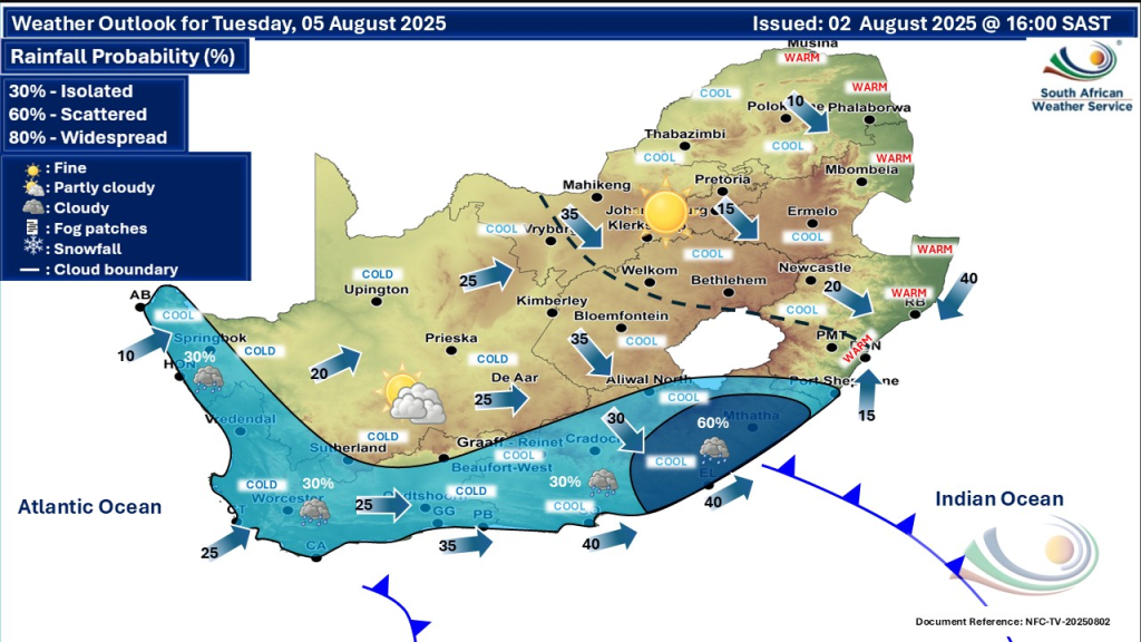
Cold Front Sweeping the Cape and Western Regions
A strong cold front continues to descend over the southwestern Cape, bringing cold, wet, and windy weather. The Western Cape is experiencing scattered to widespread showers, particularly over mountainous regions. Temperatures have dropped sharply, with cold spells dominating the interior regions. The Namakwa district in the Northern Cape and Witzenberg Municipality in the Western Cape face very cold, wet, and windy conditions.
Snow Expected in Parts of the Eastern Cape and Northern Cape
Residents in the northern high-lying areas of the Eastern Cape should prepare for light snowfall. There is also a possibility of isolated light snow in parts of the Northern Cape, especially the southern regions. This unusual but not unprecedented cold snap results from freezing levels dropping sharply due to the cold front advancing eastwards.
Rainfall and Scattered Showers Stretching Across Central and Eastern Provinces
A band of scattered showers and thunderstorms is expected to move across central South Africa, including the Northern Cape, North West, Free State, and Eastern Cape. These showers will slowly progress eastwards through the week. Rainfall may mix with sleet or snow in some areas during early Wednesday mornings, making travel conditions possibly hazardous.
Wind Warnings and Damaging Waves on the Coastline
Strong winds are forecast along much of South Africa’s coastline. Fresh to strong winds blow in the western, central, and northeastern parts of the country. Northeasterly winds are particularly strong north of Durban. Beachfront areas between Alexander Bay (Northern Cape) and Plettenberg Bay (Western Cape) face damaging waves, posing risks to beach activities and small vessels. A Yellow Level 1 warning has been issued for localised disruptions in these coastal regions.
Extremely High Fire Danger in Selected Districts
Despite the cold front, dry and windy conditions in some areas raise fire risk alerts. Extremely high fire danger warnings have been issued for parts of the western half of North West province, the northeastern parts of KwaZulu-Natal, and the Nyandeni Local Municipality in the Eastern Cape. Residents in these zones should exercise extreme caution and avoid any activities that may trigger wildfires.
Provincial Weather Snapshots for 5 August 2025
South Africa will experience a mix of cold, wet, and windy conditions as a cold front moves through. Gauteng will be fine and cool with morning frost in some southern parts. Mpumalanga will see warm and cool weather depending on the area, while Limpopo will have fine, ranging from cool to warm conditions. The North West and Free State provinces will be cool, windy, and partly cloudy with some showers expected in the west.
The Northern Cape will be cold to cool with isolated showers and thunderstorms, especially in the southwest, while the Western Cape faces cold, cloudy weather with scattered showers and very cold interior areas. The Eastern Cape’s western half will be cool with scattered showers, while the eastern half will be mostly fine and cool with some evening showers near the escarpment. KwaZulu-Natal will be mostly fine and warm but cooler inland, with moderate to strong northerly to north-easterly winds along the coast.
Gauteng:
Cool and fine with morning frost in southern parts. The UVB sunburn index is high—take precautions against sun exposure.
Mpumalanga:
Fine and cool, warm in some lowveld areas.
Limpopo:
Fine, cool to warm conditions with isolated rain showers possible in the southwest.
North West:
Cool, windy, and partly cloudy with some showers expected in parts.
Free State:
Windy, cool, becoming partly cloudy with isolated showers developing.
Northern Cape:
Cold to cool with scattered showers and some thundershowers in the west and southwest.
Western Cape:
Cold, cloudy with scattered to widespread showers, especially over the interior and mountainous areas.
Eastern Cape:
Western half sees cool and cloudy weather with showers; eastern half sees fine, cool conditions becoming partly cloudy later.
KwaZulu-Natal:
Fine and warm but becoming cool in the west with fresh to strong winds along the coast.
Safety Precautions and Advice
Residents are urged to heed weather warnings and advisories urgently. Those in coastal areas should avoid unnecessary water activities due to damaging waves. People in fire-prone regions must prepare for extremely high fire danger and follow local authority guidelines. Drivers should stay alert for slippery and icy patches in the snow-affected areas, especially in the Eastern and Northern Cape.
Stay Safe & Have A Lovely Day
As South Africa faces this week’s shifting weather, staying alert and informed is key. The cold front sweeping across the country brings snow to high-lying areas, widespread rain, strong winds, and even dangerous waves on the coast. Several provinces also grapple with extremely high fire danger due to dry and windy conditions.
Residents are advised to follow weather warnings closely, be cautious with outdoor and travel plans, and prepare appropriately. Taking simple safety steps; such as avoiding unnecessary water activities, exercising wildfire awareness, and watching for slippery roads; can make all the difference.
This dynamic and challenging weather pattern highlights the importance of vigilance as we move through early August. Staying prepared ensures everyone remains safe and ready for whatever the weather brings next. South Africa’s weather this week is shaping up to be dynamic and challenging. From snow in unexpected places to cold fronts and fire dangers, staying informed and prepared is essential to staying safe.