



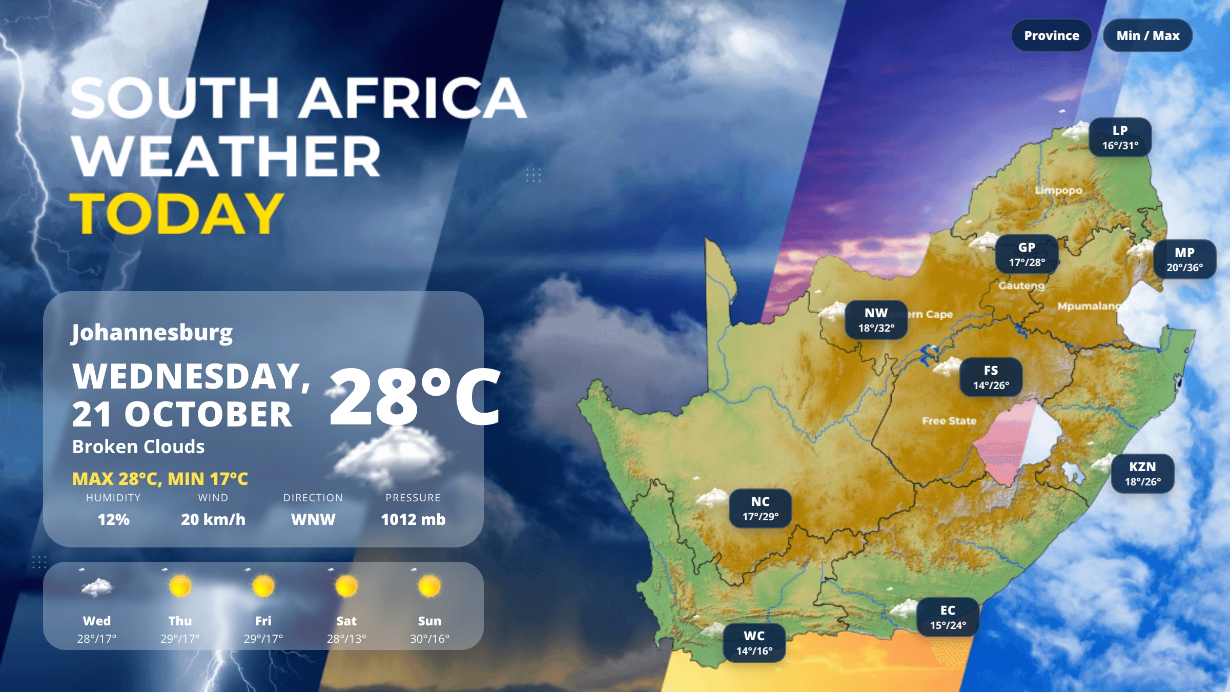
South Africa Weather Today – Wednesday, 21 October 2026
Johannesburg will see temperatures between 17°C and 28°C on Wednesday under broken cloud cover, while a sharp divide develops across the country with Mpumalanga reaching a high of 36°C and Cape Town experiencing light rain and a cool 16°C maximum. The national average stands at 23°C, with inland provinces remaining warm to hot under partly cloudy skies while the Western Cape endures unsettled, wet conditions.
What This Means for Your Day
Most inland regions will experience warm spring conditions with cloud cover providing some relief from direct sun. Cape Town residents should carry rain gear and expect cooler, damp conditions throughout the day. Mpumalanga and North West will see the hottest temperatures, requiring sunscreen and hydration. Moderate to strong winds are affecting the Free State, Northern Cape, and Western Cape, with gusts reaching up to 28 km/h in Bloemfontein and Cape Town.
South Africa Weather Highlights
- Mpumalanga records the highest temperature at 36°C in Mbombela
- Western Cape experiences the only rainfall with light showers in Cape Town
- North West and Limpopo both exceed 30°C under scattered clouds
- Coastal regions see strong winds, particularly in KwaZulu-Natal and the Western Cape
- Gauteng records very low humidity at just 12%
What to Expect Across the Provinces
Gauteng
Johannesburg will range from 17°C to 28°C with broken clouds and westerly winds gusting up to 20 km/h. Humidity remains exceptionally low at 12%, creating dry conditions. Cloud cover will persist through the afternoon, keeping temperatures comfortable but requiring sun protection during clear intervals.
Western Cape
Cape Town faces light rain with temperatures between 14°C and 16°C, accompanied by strong north-westerly winds at 28 km/h. Humidity sits at 93%, making conditions feel damp and cool. This is the wettest part of the country today, with rainfall expected to continue through the afternoon. Waterproof clothing is essential.
Mpumalanga
Mbombela will experience the hottest conditions nationally, with temperatures climbing from 20°C to 36°C under broken clouds. Westerly winds remain moderate at 13 km/h. The significant heat requires increased water intake and sun protection, particularly during midday hours when temperatures peak.
KwaZulu-Natal
Durban will see temperatures between 18°C and 26°C with broken cloud cover. South-easterly winds at 17 km/h will bring coastal breezes, while humidity reaches 66%. Conditions remain relatively comfortable compared to inland provinces, though clouds will dominate the sky throughout the day.
Limpopo
Polokwane will range from 16°C to 31°C with scattered clouds and west-north-westerly winds at 18 km/h. Humidity stands at 45%, creating warm but not oppressive conditions. The province joins the hotter inland regions, with afternoon temperatures reaching well into the low 30s.
North West
Mahikeng will experience temperatures from 18°C to 32°C under scattered clouds. West-south-westerly winds at 16 km/h and very low humidity of 9% create hot, dry conditions. This province records the second-highest maximum temperature nationally, requiring careful sun exposure management.
Free State
Bloemfontein will see temperatures between 14°C and 26°C with scattered clouds and the strongest winds nationally at 28 km/h from the west-south-west. Low humidity at 14% combines with gusty conditions to create a dry, blustery day. Outdoor items should be secured against the wind.
Northern Cape
Kimberley will range from 17°C to 29°C with broken clouds and south-westerly winds at 24 km/h. Humidity remains very low at 11%, creating arid conditions. Strong winds may cause dust in exposed areas, particularly during the afternoon.
Eastern Cape
Gqeberha will experience temperatures between 15°C and 24°C under scattered clouds. South-westerly winds at 15 km/h and moderate humidity of 56% create mild coastal conditions. Temperatures remain cooler than most inland areas but significantly warmer than the Western Cape.
Weekend Outlook
Johannesburg can expect clearing skies from Thursday, with clear conditions and temperatures reaching 29°C on both Thursday and Friday. The weekend brings slightly cooler temperatures on Saturday with a low of 13°C, before warming again to 30°C on Sunday. All weekend days show clear skies, indicating settled, dry spring weather ahead for Gauteng and likely similar patterns across inland provinces. The Western Cape may see gradual improvement after today’s rainfall.
Weather Tips for Today
- Apply high-SPF sunscreen in Mpumalanga, North West, and Limpopo where temperatures exceed 30°C
- Secure outdoor furniture and equipment in Free State, Northern Cape, and Western Cape due to strong winds
- Keep windows closed in dry provinces like Gauteng and North West to prevent dust entry
- Carry waterproof jackets and umbrellas in Cape Town throughout the day
- Increase water intake in hot, low-humidity areas including North West and Northern Cape
- Dress in layers for Johannesburg’s 11-degree temperature range between morning and afternoon
Useful Weather and Travel Links
Looking for more to do after checking the forecast? Explore the latest events in Gauteng and plan your day around the weather.
You can also browse our weather category for more South Africa weather updates and recent forecast articles.
For official forecasting and weather advisories, visit the South African Weather Service.
Last updated: 25 February 2026
This weather hub covers Gauteng-focused alerts, daily forecast context, and practical preparation tips.
Today in Gauteng
Check current alert conditions, possible impact areas, and likely weather trends for the next 24 hours.
7-Day Snapshot
Use this hub to understand short-term changes in rain risk, heat conditions, and storm activity.
Where To Track Live Updates
Safety Checklist
- Plan around severe storm windows.
- Avoid flood-prone routes where possible.
- Monitor official warnings before travel.
FAQ
How often is this page updated?
As new weather alerts and forecast updates are published.