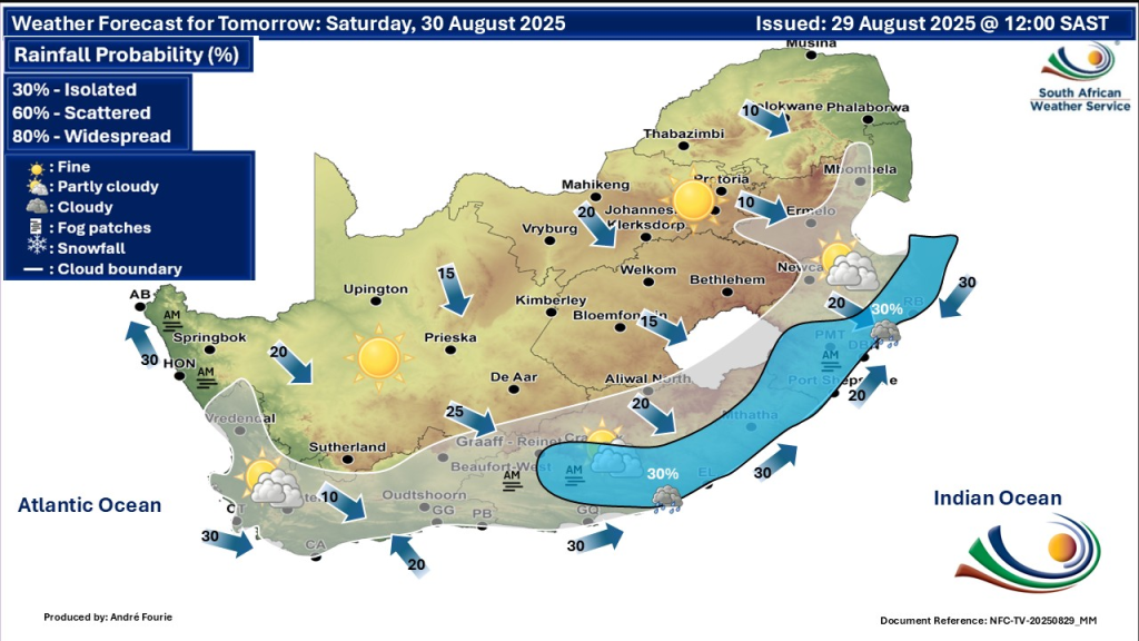
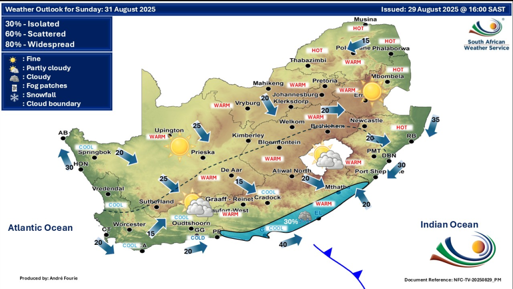
South Africa is entering a transitional weather period, this weekend, for Saturday, 30 August 2025 and Sunday, 31 August 2025. A mix of clear, warm, and hot conditions will prevail across many regions, while parts of the coastal south and east will experience precipitation and drifting mist. This article provides detailed updates and weather warnings by province, helping residents stay safe and prepared.
SEE FULL FORECAST: Today’s Weather Forecast – Saturday, 30 August 2025
Table of contents
- Warm to Hot Conditions Dominate Central and Northeastern Areas
- Cool to Mild Weather in the South and Coastal Regions
- Showers and Thunderstorms in KwaZulu-Natal and Eastern Cape
- Fire Danger Alerts for Northern KwaZulu-Natal, Mpumalanga, and Limpopo
- Windy Conditions Along Coastal Areas
- Stable and Pleasant Weather in Northern and North-Western Provinces
- Detailed Provincial Weather Summaries
- Warnings Summary
- Stay Safe & Have A Lovely Weekend
Warm to Hot Conditions Dominate Central and Northeastern Areas
Across Limpopo, Mpumalanga, and parts of the Free State, the weather will heat up significantly. Temperatures are forecast to rise above 30°C, with some areas seeing highs near 32°C. These conditions increase the risk for heat-related health issues. People are encouraged to stay hydrated, avoid prolonged sun exposure, and monitor vulnerable individuals during peak heat hours.
Cool to Mild Weather in the South and Coastal Regions
The Western Cape, parts of the Eastern Cape, and coastal KwaZulu-Natal will experience cooler, milder temperatures ranging from 14°C in the early mornings to around 20°C during the day. Light drizzle or isolated showers are possible, mainly in the afternoon and evening. This change is linked to a weak cold front moving through the south-western parts of the country, bringing cloud cover and occasional light rain.
Showers and Thunderstorms in KwaZulu-Natal and Eastern Cape
Residents in KwaZulu-Natal and parts of the Eastern Cape should prepare for isolated afternoon and evening showers. Thunderstorms may develop, particularly in the afternoon, causing sudden pockets of heavy rain. Morning fog and mist will reduce visibility, especially along coastal roads, calling for increased caution while driving.
Fire Danger Alerts for Northern KwaZulu-Natal, Mpumalanga, and Limpopo
An extremely high fire risk is in place for northern KwaZulu-Natal, eastern Mpumalanga, and central to northern Limpopo on August 30. These conditions require heightened awareness from all residents. Avoid open flames, stay clear of fire-prone areas, and follow any issued local fire safety instructions to prevent wildfires.
Windy Conditions Along Coastal Areas
Expect fresh to strong southwesterly winds along the KwaZulu-Natal coast and parts of the Western Cape this weekend. These winds create a chill effect but also increase fire spread risks in already dry regions. Coastal fog will commonly form during the early morning hours, further reducing visibility for marine and road users.
Stable and Pleasant Weather in Northern and North-Western Provinces
Northern Cape, North West, and parts of Gauteng will enjoy partly cloudy skies with no significant rain. Temperatures will range from cool mornings of about 8°C up to warm afternoons around 25-27°C. These conditions are ideal for outdoor activities and travelling.

Detailed Provincial Weather Summaries
Across South Africa’s provinces, the weather varies significantly due to diverse geography and climate zones. These variations highlight the importance of tracking local conditions and preparing for both heat and wet weather as needed across the regions.
Gauteng
Daytime temperatures will reach the low to mid-20s Celsius with mostly sunny skies. Calm mornings will warm quickly, making for a comfortable late winter day. No precipitation or severe weather is expected.
Western Cape
Cape Town and surrounding areas will experience cool mornings with possible early drizzle. Daytime temperatures remain mild, accompanied by increasing cloud cover. Winds will strengthen later on Sunday, so plan activities accordingly.
KwaZulu-Natal
Morning fog will blanket coastal towns like Durban and Richards Bay. Isolated showers and thunderstorms are likely in the afternoon and evening, so carry rain gear and exercise caution in traffic.
Eastern Cape
Showers will affect cities such as Port Elizabeth and East London. Thunderstorms might develop in some areas. Dry spells will alternate with cloudy and wet periods.
Free State
Relatively warm and sunny weather is expected. Bloemfontein will see highs near 23°C with clear skies, creating favourable outdoor conditions.
Limpopo and Mpumalanga
Hot weather dominates with highs above 30°C. The increased heat will necessitate precautions against dehydration and sunstroke.
Northern Cape and North West
Stable weather conditions prevail here with partly cloudy skies, low chances of rain, and moderate temperatures.

Warnings Summary
- Fire Danger: Extremely high on August 30 in northern KwaZulu-Natal, eastern Mpumalanga, and Limpopo.
- Rain and Thunderstorms: Possible in KwaZulu-Natal and Eastern Cape.
- Fog: Coastal and some inland fog on mornings of both days.
- Wind: Strong coastal winds, especially Sunday.
- Heat: Temperatures exceeding 30°C in parts of the northeast and central areas.
Stay Safe & Have A Lovely Weekend
South Africans are encouraged to stay informed by monitoring updates from the South African Weather Service and official social media platforms. Taking timely precautions will help reduce risks related to heat, fire, fog, and rain. This period’s diverse weather underscores the importance of being prepared for sudden changes, especially when travelling across provinces with different climatic conditions.
Whether you reside in the coastal south or the hotter northeast, understanding the upcoming weather pattern can help ensure safety and comfort in daily activities.


