
Extreme and shifting weather patterns are bringing a mix of hazards across several South African provinces this week. On Thursday, 28 August 2025 and the coming days, residents should stay alert to multiple warnings issued by the South African Weather Service. The main threats include severe thunderstorms, high fire danger, and fog in some regions. This article provides detailed, up-to-date information to help communities prepare and stay safe.
SEE FULL FORECAST: Today’s Weather Forecast – Thursday, 28 August 2025
Table of contents
- High Fire Danger Areas Demand Caution
- Severe Thunderstorm Threats in Northern Cape and Surrounding Areas
- Weather in Gauteng and Adjacent Provinces
- Eastern and Western Cape: Cooler, Foggy with Chance of Showers
- KwaZulu-Natal Weather Outlook
- Fog and Low Visibility Hazards
- Heat and UV Exposure Hazards
- Summary of Weather Warnings by Province
- Safety Tips for Residents
- Reliable Information Sources
- What Residents Must Know Right Now
- Stay Connected and Stay Safe
High Fire Danger Areas Demand Caution
Several provinces are under extreme fire danger warnings due to hot, dry, and windy conditions. The Northern Cape’s Kai !Garib Municipality, Limpopo’s Blouberg and Makhado Municipalities, parts of Gauteng, Free State, and Mpumalanga are especially vulnerable. Fire danger indexes are at extreme levels, signaling rapid fire ignition and spread risks. Residents should avoid open flames, burning, and activities that could spark wildfires. Strict adherence to fire safety regulations is vital given how quickly fires can escalate during these dry conditions.
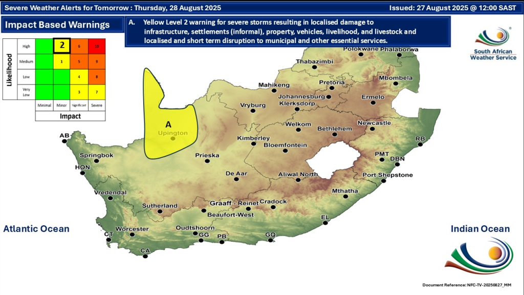
Severe Thunderstorm Threats in Northern Cape and Surrounding Areas
A cut-off low pressure system moving across Namibia is driving a bank of clouds, thunderstorms, and showers into northern parts of Northern Cape and western provinces. On 28 August, an Environment Yellow Level 2 Warning exists for severe thunderstorms that can damage infrastructure, vehicles, livestock, and interrupt municipal services in extreme northern Northern Cape.
These storms may also bring localized flooding and strong winds. People in the affected regions should avoid outdoor activities during storm windows and secure loose outdoor objects. Emergency services are on alert in vulnerable areas.
Weather in Gauteng and Adjacent Provinces
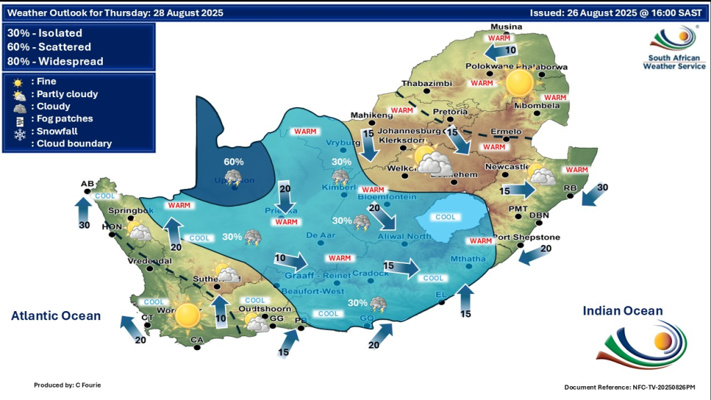
Gauteng is experiencing warm, dry, and mostly clear weather with high UV sunburn indexes. Evening winds pick up, increasing fire spread potential. Residents must avoid open fires and reduce outdoor burning. Temperatures in Pretoria and Johannesburg range from the low 20s Celsius in the morning to highs of about 30°C. Some evening breezes raise fire risk despite no expected rainfall.
Eastern and Western Cape: Cooler, Foggy with Chance of Showers
The Western Cape has a cooler start with fog patches, especially along the coast and interior. Temperatures range from around 10°C in the morning to mid-20s in the afternoon. Sporadic showers and thunderstorms are expected later in parts of Eastern Cape, especially in the northern and coastal areas. The east and west of the province experience partly cloudy skies. Winds remain moderate, lessening fire risk here, but residents should remain cautious.
KwaZulu-Natal Weather Outlook
KwaZulu-Natal’s northern coastal areas see warm temperatures close to 30°C with isolated showers and thunderstorms possible. Other parts of the province will be partly cloudy to cloudy, with cooler early mornings. Nighttime and early-morning fog patches may reduce visibility near coastlines, affecting traffic safety. Winds are light to moderate.
Fog and Low Visibility Hazards
In a few western and southern coastal regions, morning fog patches are a concern. Drivers should exercise caution due to limited visibility, especially during early hours and at dawn. These foggy conditions are expected to persist intermittently into the weekend.
Heat and UV Exposure Hazards
Across the affected provinces, the sun’s UV index remains moderate to high. South Africans should protect themselves by wearing hats, sunscreen, and light clothing. Drink plenty of water to avoid dehydration. Prolonged heat exposure, especially during mid-day hours, risks heat exhaustion and heat stroke in vulnerable groups.
Summary of Weather Warnings by Province
| Province | Warning | Key Weather Conditions |
|---|---|---|
| Northern Cape | Severe thunderstorms (Level 2) | Thunderstorms, showers, strong winds |
| Northern Cape | Extreme fire danger | Hot, dry, windy conditions |
| Limpopo | Extreme fire danger | Hot, dry, windy |
| Gauteng | High fire danger & UV warning | Warm, dry, high UV, evening winds |
| Free State | High fire danger warning | Warm, dry, windy |
| Mpumalanga | High fire danger warning | Warm, dry |
| Western Cape | Fog, cooler temperatures | Morning fog, partly cloudy, cooler temps |
| Eastern Cape | Showers and thunderstorms | Isolated showers and storms, partly cloudy |
| KwaZulu-Natal | Isolated showers, fog patches | Cloudy, warm, fog near coast |
Safety Tips for Residents
- Avoid open flames and refrain from outdoor burning in fire risk zones.
- Keep water sources ready for firefighting if needed.
- Monitor local news and weather updates through trusted sources.
- Limit outdoor activities during severe storms and heat waves.
- Drive cautiously during foggy conditions due to reduced visibility.
- Protect skin and eyes from strong sun exposure.
- Stay hydrated, especially during hot afternoons.
Reliable Information Sources
For accurate and timely weather alerts, consult the official South African Weather Service website, which provides locally relevant weather news.
What Residents Must Know Right Now
The mix of severe weather threats requires communities to remain prepared and cautious. Especially in fire-prone provinces like Northern Cape and Limpopo, the risk of wildfires is very high. Severe thunderstorms could lead to wind damage in the northern part of Northern Cape. Meanwhile, the coastal provinces face cooler, foggy mornings with patchy showers that may impact travel. Awareness and preventive actions now can reduce dangers in the days ahead.
Stay Connected and Stay Safe
Check weather forecasts daily. Sign up for area-specific alerts. Follow safety guidance from local authorities and emergency services. Preparation is the best defence against the impacts of these severe weather systems.