
South Africa faces a cooler and unsettled weather pattern on Friday, 25 July 2025, as a cold front moves across the south-western regions, bringing cloudy skies, light rain, and isolated showers to much of the country. The South African Weather Service (SAWS) has issued important weather warnings for several provinces including severe thunderstorm alerts and a marine warning for damaging waves. Residents are advised to stay informed and take precautions as wet and windy conditions persist across various areas.
SEE FULL FORECAST: Today’s Weather Forecast
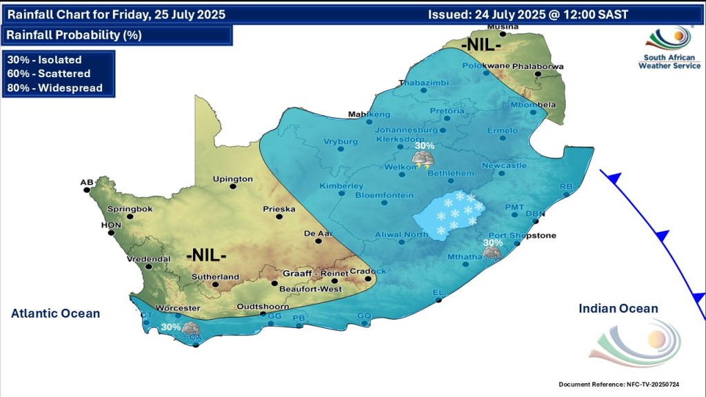
National Weather Overview
A cold front sweeping over the south-western Cape is ushering in chilly temperatures alongside cloud cover and light showers. This cold front will extend its influence to the Western and Eastern Cape throughout the day. Meanwhile, isolated showers and thundershowers remain likely over central and eastern regions like the Free State, KwaZulu-Natal, Eastern Cape, Mpumalanga, and Limpopo. Temperatures will generally stay cool to cold, especially during the early mornings across the interior provinces.
Weather Warnings to Note
- Damaging Waves Warning: A Yellow Level 2 warning is active for damaging waves south of Durban, expected to disrupt navigation and beachfront activities until Saturday midnight.
- Severe Thunderstorm Alerts: Yellow Level 2 warnings have been issued for severe thunderstorms with possible hail, strong winds, excessive lightning, and heavy rain over southern and western KwaZulu-Natal from Friday afternoon until Saturday evening. Similar warnings apply for Gauteng, Mpumalanga, and Limpopo (excluding northern and extreme south-west regions) for the same period. These storms may cause local infrastructure damage, disrupt services, and pose safety risks.
- No Fire Danger Warnings are currently active for the country, given the wet conditions.
Provincial Weather Updates
Gauteng
Gauteng residents will experience partly cloudy, cool weather with isolated showers and thundershowers likely. The UVB index is high, so sun protection is advised.
Western Cape
Expect cloudy, cold conditions along the coast and inland areas with light morning rain spreading along the south coast. Morning fog patches occur over the Overberg and southern interior. Motorists should exercise caution in fog-prone regions due to reduced visibility.
Eastern Cape
Overcast and cooler weather prevails with isolated showers and thundershowers, particularly in southern and eastern parts. Temperatures remain mild but cool.
KwaZulu-Natal
Cloudy skies and cool conditions dominate with isolated showers and thundershowers likely, especially over western, southern, and western parts. Warmer conditions persist in the extreme northeast. Be alert for severe thunderstorms with hail, damaging winds, and heavy rain possible.
Mpumalanga
Partly cloudy and cool weather prevails, warming up in the Lowveld. Isolated afternoon showers and thundershowers may develop over the Highveld.
Limpopo
A partly cloudy day with cool to warm temperatures and isolated showers and thundershowers in southwestern areas.
Free State
Partly cloudy skies with cold to cool temperatures. Isolated showers and thundershowers are expected, particularly in eastern parts. Winds may increase locally.
North West
Cool, partly cloudy conditions with isolated showers and thundershowers. Expect windy spells in eastern areas during the afternoon.
Northern Cape
Morning fog patches are anticipated over the southwestern interior. Otherwise, partly cloudy and cool weather with isolated showers and thundershowers in the east. Cold conditions persist in southern regions.
Safety and Preparedness
Residents in affected areas should prepare for possible disruptions from severe weather, particularly in KwaZulu-Natal, Gauteng, Mpumalanga, and Limpopo. Precautions include securing loose objects, avoiding unnecessary travel during storms, and staying updated with forecasts. Coastal communities near Durban should heed warnings about damaging waves and avoid risky beachfront activities.
Stay Safe & Warm
The cold front will gradually move off by the weekend, with weather conditions expected to stabilise and temperatures to slowly rise. However, scattered showers and thunderstorms remain possible in eastern and central provinces for the next few days.
South Africans should stay alert to rapidly changing weather conditions through Friday and the following days. The South African Weather Service website and official communication channels remain the best sources for real-time updates and warnings.