
Table of contents
- Weather Alert: Snow, Rain and Sleet Sweep Across Gauteng and Surrounding Provinces for 7 August 2025
- Severe Thunderstorm Warnings in Gauteng and Surrounding Provinces
- Cold Conditions and Frost Across the Country
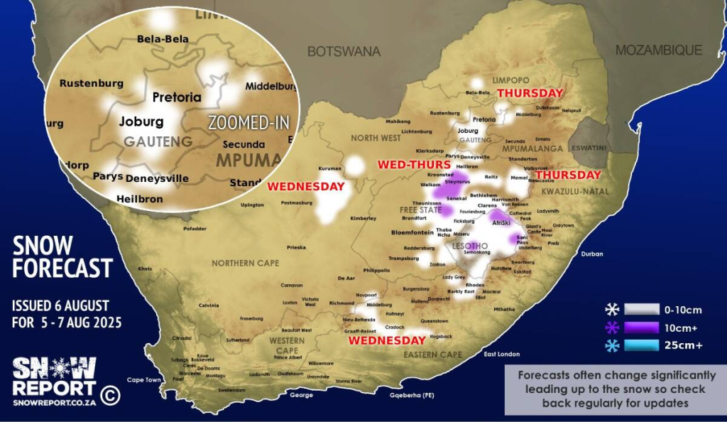
- Snow and Sleet in High-Lying Areas
- Provincial Weather Summaries for 7 August 2025
- No Current Wildfire Alerts
- Emergency Services Preparedness
- Travel and Safety Tips
- Understanding Key Weather Terms
- Weather Outlook Beyond 7 August
Weather Alert: Snow, Rain and Sleet Sweep Across Gauteng and Surrounding Provinces for 7 August 2025
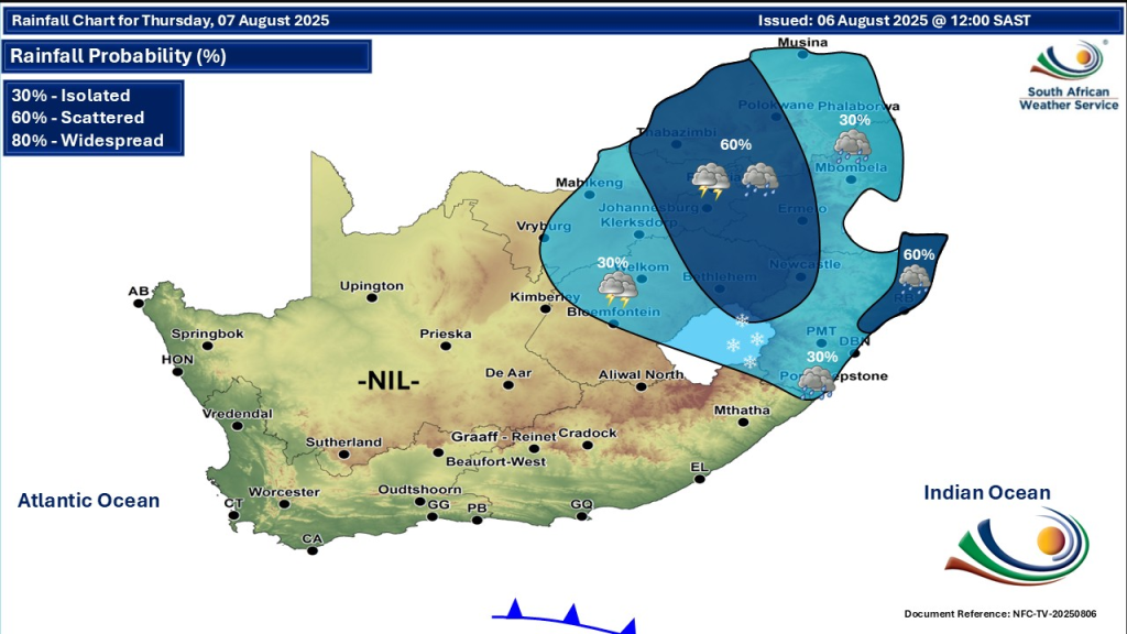
South Africa faces a significant weather event on Thursday, 7 August 2025. The South African Weather Service (SAWS) has issued impactful warnings covering Gauteng, Limpopo, Mpumalanga and neighbouring provinces. Residents and travellers must prepare for severe thunderstorms, cold temperatures, scattered showers, snow, sleet, hail and localized flooding over the coming days.
SEE FULL FORECAST: Today’s Weather Forecast – 7 August 2025
Severe Thunderstorm Warnings in Gauteng and Surrounding Provinces
SAWS has issued a Yellow Level 3 warning alerting residents of Gauteng, Limpopo, and most of Mpumalanga Highveld about severe thunderstorms that may cause:
- Travelling disruptions
- Localized flooding
- Large amounts of small hail
- Wind damage
These warnings are valid through Thursday, 7 August, and possibly longer as the system evolves. Residents should take extra care when out and about, especially motorists on affected routes. Prepare for sudden weather changes and avoid unnecessary travel during storms.
Cold Conditions and Frost Across the Country
Accompanying the storms is a strong cut-off low-pressure system moving eastwards. This will result in very cold conditions especially in:
- Gauteng: Cloudy, cold with scattered showers and thundershowers; temperatures dropping to around 7°C overnight.
- Limpopo and Mpumalanga: Cold with isolated to scattered showers.
- Cape Interior: Widespread frost expected, with temperatures as low as -6°C in certain areas.
- Free State and Eastern Provinces: Cold with rain, sleet, and possible snow on high mountain peaks.
Early morning frost will particularly affect the Cape Interior, posing risks to sensitive crops and outdoor activities. Dress warmly if you must be outdoors.
Snow and Sleet in High-Lying Areas
The cold front will bring light snowfalls and sleet to northern high-lying areas, notably parts of the Free State, Gauteng, and surrounding mountain regions until Friday, 8 August. While snow accumulation will be light, such precipitation is unusual in August and could disrupt local travel.
The phenomenon of sleet here refers to rain that freezes as it falls, creating icy conditions. Motorists are urged to drive carefully where sleet or snow has formed.
Provincial Weather Summaries for 7 August 2025
Gauteng
Cloudy and cold, scattered showers and thunderstorms possible. UVB sunburn index high, limit prolonged sun exposure.
Limpopo
Cloudy to cold with isolated showers and thunderstorms, especially in western regions.
Mpumalanga
Cloudy, cold with isolated showers mostly in the east.
North West
Partly cloudy and cold, isolated to scattered showers.
Free State
Partly cloudy, cold with isolated showers and chance of snow on high ground.
Northern Cape
Partly cloudy, cold to cool weather.
Western Cape
Partly cloudy, cold to cool with frost inland.
Eastern Cape
Partly cloudy and cool, colder on high ground with light morning rain along the coast.
KwaZulu-Natal
Cloudy, cool to cold with isolated showers and rain in certain regions.
No Current Wildfire Alerts
The wet, cold conditions reduce the risk of wildfires. No fire danger warnings have been issued by SAWS currently. However, residents should remain vigilant in the drier northern areas until rains become consistent.
Emergency Services Preparedness
Emergency services across South Africa are fully mobilised and prepared to respond to the severe weather conditions impacting Gauteng and surrounding provinces. The National Disaster Management Centre (NDMC), together with provincial and local disaster management teams, is on high alert to coordinate rapid response and relief efforts where needed. These multi-disciplinary teams include officials from the South African Police Service, departments of water and sanitation, transport, social development, and human settlements, working closely to address emergencies such as flooding, road closures, and power outages.
Following the recent serious weather events, emergency services have been praised for their proactive road clearance and rescue operations, especially in provinces like the Eastern Cape and KwaZulu-Natal. Residents are urged to remain vigilant and heed official warnings, as these agencies stand ready to deploy resources, provide emergency shelter, deliver clean water, and offer psychosocial support to affected communities. The emphasis on collaboration among various government sectors, social partners, and NGOs reflects a strong commitment to safeguarding lives and property during this challenging weather period.
Travel and Safety Tips
- Check the latest weather updates from SAWS regularly.
- Avoid travel during severe thunderstorms to reduce flood and hailstorm risk.
- Layer clothing to stay warm; frosty mornings call for coats and gloves.
- Be cautious on roads with sleet or icy patches.
- Protect skin during periods of high UVB radiation despite cold conditions.
- Secure loose outdoor objects as strong winds may cause damage.
Understanding Key Weather Terms
- Cut-off Low (COL): A weather system causing cold conditions and storms by trapping cold air over a region.
- Yellow Level 3 Warning: Indicates potentially dangerous weather conditions that could disrupt daily activities.
- Sleet: Rain that freezes before it hits the ground, creating icy surfaces.
- Frost: Formation of ice crystals when temperatures fall below freezing, common early morning.
Weather Outlook Beyond 7 August
Cold and wet weather will continue until Friday, 8 August, with easing temperatures expected over the weekend. A cold front is expected to reach the Western Cape on Saturday, bringing rains and isolated showers along the coast and interior western regions.
Residents should monitor updates from official sources like the South African Weather Service for ongoing alerts.